
Page 48 - Green - Maritime Archaeology: A Technical Handbook. 2nd ed
P. 48
Chapter 3: Search and Survey 27
c
d
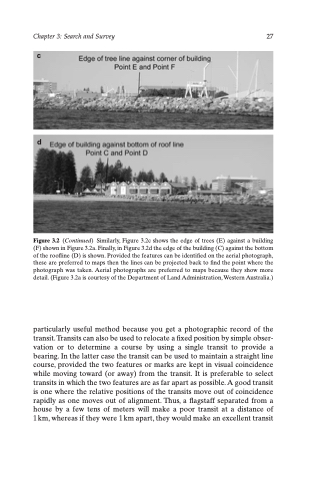
Figure 3.2 (Continued) Similarly, Figure 3.2c shows the edge of trees (E) against a building (F) shown in Figure 3.2a. Finally, in Figure 3.2d the edge of the building (C) against the bottom of the roofline (D) is shown. Provided the features can be identified on the aerial photograph, these are preferred to maps then the lines can be projected back to find the point where the photograph was taken. Aerial photographs are preferred to maps because they show more detail. (Figure 3.2a is courtesy of the Department of Land Administration, Western Australia.)
particularly useful method because you get a photographic record of the transit. Transits can also be used to relocate a fixed position by simple obser- vation or to determine a course by using a single transit to provide a bearing. In the latter case the transit can be used to maintain a straight line course, provided the two features or marks are kept in visual coincidence while moving toward (or away) from the transit. It is preferable to select transits in which the two features are as far apart as possible. A good transit is one where the relative positions of the transits move out of coincidence rapidly as one moves out of alignment. Thus, a flagstaff separated from a house by a few tens of meters will make a poor transit at a distance of 1 km, whereas if they were 1 km apart, they would make an excellent transit
