
Page 504 - UK Air Operations Regulations (Consolidated) 201121
P. 504
~
~ Regulation SPA - ANNEX V - Specific Approval Operations Centrik
(2) On passing the FAP, the helicopter will descend below the intermediate approach
altitude and follow a descent gradient which should not be steeper than 6.5 %. At
this stage, vertical separation from the offshore obstacle environment will be lost.
However, within the final approach area, the MDA/MDH will provide separation from
the surface environment. Descent from 1 000 ft AMSL to 200 ft AMSL at a constant
6.5 % gradient will involve a horizontal distance of 2 nm. In order to follow the
guideline that the procedure should not generate an unacceptably high workload for
the flight crew, the required actions of levelling off at MDH, changing heading at the
offset initiation point (OIP), and turning away at the MAPt, should not be planned to
occur at the same time from the destination.
(3) During the final approach, compensation for drift should be applied, and the heading
which, if maintained, would take the helicopter directly to the destination should be
identified. It follows that at an OIP located at a range of 1.5 nm, a heading change of
10° is likely to result in a track offset of 15° at 1 nm, and the extended centre line of
the new track can be expected to have a mean position approximately 300-400 m to
one side of the destination structure. The safety margin built into the 0.75-nm
decision range (DR) is dependent upon the rate of closure with the destination.
Although the airspeed should be in the range of 60-90 KIAS during the final
approach, the ground speed, after due allowance for wind velocity, should not be
greater than 70 kt.
(g) Missed approach segment
(1) The missed approach segment commences at the MAPt and ends when the
helicopter reaches the minimum en route altitude. The missed approach
manoeuvre is a ‘turning missed approach’ which should be of not less than 30° and
should not, normally, be greater than 45°. A turn away of more than 45° does not
reduce the collision risk factor any further nor does it permit a closer DR. However,
turns of more than 45° may increase the risk of pilot disorientation, and by inhibiting
the rate of climb (especially in the case of an OEI missed approach procedure),
may keep the helicopter at an extremely low level for longer than it is desirable.
(2) The missed approach area to be used should be identified and verified as a clear
area on the radar screen during the intermediate approach segment. The base of
the missed approach area is a sloping surface at 2.5 % gradient starting from MDH
at the MAPt. The concept is that a helicopter executing a turning missed approach
will be protected by the horizontal boundaries of the missed approach area until
vertical separation of more than 130 ft is achieved between the base of the area
and the offshore obstacle environment of 500 ft AMSL that prevails outside the area.
(3) A missed approach area, taking the form of a 45° sector orientated left or right of
the final approach track, originating from a point 5 nm short of the destination, and
terminating on an arc 3 nm beyond the destination, should normally satisfy the
specifications of a 30° turning missed approach.
(h) Required visual reference
The visual reference required is that the destination should be in view in order to be able
to carry out a safe landing.
(i) Radar equipment
During the ARA procedure, colour mapping radar equipment with a 120° sector scan and
a 2.5nm range scale selected may result in dynamic errors of the following order:
(1) bearing/tracking error of ± 4.5° with 95 % accuracy;
(2) mean ranging error of 250 m; or
(3) random ranging error of ± 250 m with 95 % accuracy.
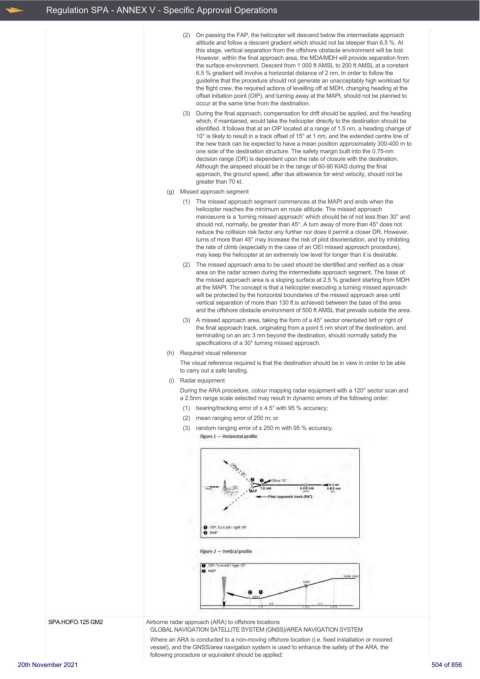
Figure 1 - Horizontal profile
,II
0 OIF': Tlrn Jett/ rgtll 10~
0 MAP
Figure 2 - Vertical profile
18 OIP; Tum left. / riliJh1 ~ O'"
8 MAJ>
·~ --
I
8 0 ----- : :
M ~ I I
--- I I I I
I I 2.0 I 20 I
SPA.HOFO.125 GM2 Airborne radar approach (ARA) to offshore locations
GLOBAL NAVIGATION SATELLITE SYSTEM (GNSS)/AREA NAVIGATION SYSTEM
Where an ARA is conducted to a non-moving offshore location (i.e. fixed installation or moored
vessel), and the GNSS/area navigation system is used to enhance the safety of the ARA, the
following procedure or equivalent should be applied:
20th November 2021 504 of 856