
Page 36 - ARQUEOLOGIA IBEROAMERICANA
P. 36
36 ARQUEOLOGIA IBEROAMERICANA 2 (2009) ISSN 1989–4104
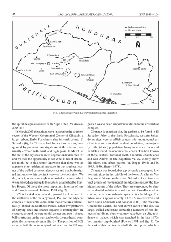
Fig. 1. El Salvador with major Precolumbian sites indicated.
the spiral design associated with Xipe Tótec (Valdivieso gests it was to be an important addition to the civic/ritual
2005:21). complex.
In March 2003 the authors were inspecting the southern Cihuatán is an urban site, the earliest to be found in El
sector of the Western Ceremonial Center of Cihuatán, a Salvador. Prior to the Early Postclassic, western Salva-
large, urban, Early Postclassic site in north central El doran sites were smallish centers with monumental ar-
Salvador (fig. 1). This area had, for various reasons, been chitecture and a modest resident population, the majori-
ignored by previous investigations at the site and was ty of the (dense) population living in smaller towns and
usually covered with brush and high grass. In March, at hamlets around the monumental center. The best known
the end of the dry season, most vegetation had burned off of these centers, Tazumal (within modern Chalchuapa)
and we took the opportunity to see what kinds of structu- and San Andrés in the Zapotitán Valley, clearly show
res might be in this sector, knowing that there was an this older, non-urban pattern (cf. Boggs 1944a and b,
apparent elite residential structure in the southeast cor- 1945, 1950; Sharer 1978).
ner of the walled ceremonial precinct and that both origi- Cihuatán was founded on a previously unoccupied low
nal entrances to this precinct were on the south side. We volcanic ridge in the middle of the lower Acelhuate Va-
did, in fact, locate some eight unreported structures, which lley, some 34 km north of San Salvador. Here two dis-
we numbered according to the system established by Stan- tinct groups of monumental architecture occupy the two
ley Boggs. Of these the most important, in terms of size highest points of the ridge. They are surrounded by den-
and form, is a round platform, P-28 (fig. 2). se residential architecture and a series of smaller satellite
P-28 is located near the wide, ground level entrance to centers, perhaps suburban temples or civic buildings. The
the southwest of the main pyramid, P-7, and the adjacent urban area is approximately 1.4 x 2.5 km east-west and
complex of residential/administrative structures infelici- north-south (Amaroli and Amador 2003). The Western
tously labeled the Southeast Patios. Other low platforms Ceremonial Center, the best known sector of the site, is a
of varying sizes and shapes (square to rectangular) are large, walled enclosure containing numbers of non-do-
scattered around the ceremonial center and two I-shaped mestic buildings, plus what may have been an elite resi-
ball courts, one on the west and one in the northeast, com- dence or palace, which was trenched in the late 1970s
plete the ceremonial center (fig. 3). The position of P-28 but remains unpublished (Fowler 1981 and fig. 3). To
close to both the main original entrance and to P-7 sug- the east of this precinct is a hill, the Acropolis, which is