
Page 80 - Algarve Road Cycling
P. 80
CyCLE RoutEs | ClIMATIC ChARACTeRIsATION
clIMatIc
characterIsatIon
ACCORDING TO The kOPPeN ClIMATe ClAssIfICATION,
The AlGARve COMes UNDeR The fOllOwING:
csa csB
TeMPeRATe ClIMATe wITh hOT, TeMPeRATe ClIMATe wITh
DRy sUMMeRs wARM, DRy sUMMeRs.
in the inland areas of the Algarve and the south
coast of the eastern Algarve.
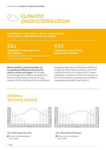
where rainfall is concerned, there are Average rainfalls vary with altitude, with Fóia, at
no significant differences between the an altitude of 902 metres recording 1,526.1 mm
stations of faro and sagres. the average and Praia da Rocha, at an altitude of 21 metres,
annual temperature variation along the coast registering a minimum of 454.6 mm. However, as
(sotavento/Barlavento) is around 1ºC (e.g. far as the coastline is concerned, the variation in
between Vila Real de santo António and sagres). average annual rainfall is practically nil.
norMal
weather charts
Rainfall mm temperature ºC Rainfall mm temperature ºC
Jan Feb Mar Apr May Jun Jul Aug sep oct nov Dec Jan Feb Mar Apr May Jun Jul Aug sep oct nov Dec
Km
Months Months
Km
1961-1990 | Climate Chart faro 1961-1990 | Climate Chart sagres
Average annual temperature Average annual temperature
total rainfall total rainfall
78