
Page 277 - Ranah Studi Agraria: Penguasaan Tanah dan Hubungan Agraris
P. 277
Ranah Studi Agraria
appear in tables (Village I–Village VIII).
It should be noted that, in contrast to the previous pre-
liminary report (see Wiradi, Manning and Sri Hartoyo, 1984),
no analysis has been conducted by aggregating data from the
groups of lowland and upland villages. Owing to quite substan-
tial inter village differences especially in land tenure and em-
ployment structure, and to the small size of the sample, it was
felt that aggregation of this nature can provide a misleading
picture of lowland and upland contrasts; what appears to be a
prominent feature of one group in reality frequently reflects
the pattern of one village only. Disaggregation complicates
exposition but does provide a clearer picture of considerable
diversity, one of the themes of this paper.
In the following sub section a brief overview is presented
on general village conditions, prior to a more detailed discus-
sion of sawah patterns in Section C.
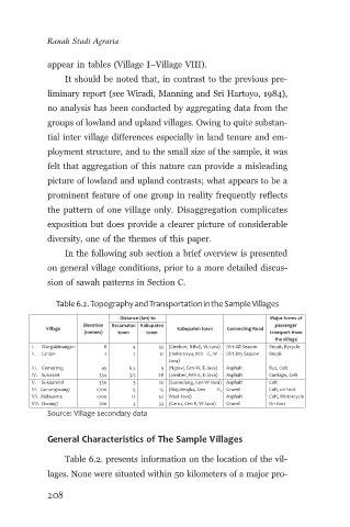
Table 6.2. Topography and Transportation in the Sample Villages
Distance (km) to Major forms of
Elevation Kecamatan Kabupaten passenger
Village Kabupaten town Connecting Road
(meters) town town transport from
the village
I. Wargabinangun 8 4 35 (Cirebon, Nth-E, W-Java) Dirt-All Season Becak, Bycycle
II. Lanjan 2 7 17 (Indramayu, Nth -E, W - Dirt-Dry Season Becak
Java)
III. Gemarang 45 6.5 9 (Ngawi, Cen-W, E-Java) Asphalt Bus, Colt
IV. Sukosari 334 3.5 28 (Jember, Nth-E, E-Java) Asphalt Carriage, Colt
V. Sukaambit 330 3 10 (Sumedang, Cen-W-Java) Asphalt Colt
VI. Gunungwangi >700 5 15 (Majalengka, Cen -E, Gravel Colt, on foot
VII. Malausma >700 12 52 West Java) Asphalt Colt, Motorcycle
VIII. Ciwangi 700 3 33 (Garut, Cen-E, W-Java) Gravel On foot
Source: Village secondary data
General Characteristics of The Sample Villages
Table 6.2. presents information on the location of the vil-
lages. None were situated within 50 kilometers of a major pro-
208