
Page 59 - Environment: The Science Behind the Stories
P. 59
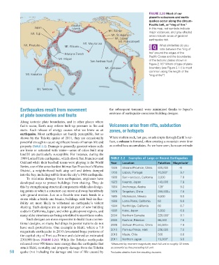
Figure 2.20 Most of our
                                                                                                   planet’s volcanoes and earth-
                                                                                                 quakes occur along the circum-
                                                   Aleutian                                      Pacific belt, or “ring of fire.”
                             Japan                  Islands                                      In this map, red symbols indicate
                                                                         Mt. Rainier
                           Mt. Fuji                                                              major volcanoes, and gray-shaded
                                                                           Mt. St. Helens        areas indicate areas of greatest
                                                                             Mt. Lassen          earthquake risk.
                                                                               Mt. Popocatepetl
                                                          Mt. Mauna Loa
                       Mt. Pinatubo            Mt. Kilauea                                             What similarities do you
                                                                                                       note between the “ring of
                                               Mariana Trench                                    fire” around the edges of the
                                                                                                 Pacific Ocean and the boundaries
                                           Mt. Mayon
                                                              San Andreas Fault                  of the tectonic plates shown in
                                                                                                 Figure 2.16? Which of type of plate
                                                                       Mt. Cotopaxi              boundary (see Figure 2.17) is most
                                                                                                 common along the length of the
                        Mt. Krakatoa                                                             “ring of fire”?


                               Mt. Tambora


                     Earthquakes result from movement                     the  subsequent  tsunami)  were  minimized  thanks  to  Japan’s
                     at plate boundaries and faults                       embrace of earthquake-conscious building designs.

                     Along tectonic plate boundaries, and in other places where
                     faults occur, Earth may relieve built-up pressure in fits and   Volcanoes arise from rifts, subduction
                     starts. Each release of energy causes what we know as an   zones, or hotspots
                     earthquake. Most earthquakes are barely perceptible, but as
                     shown by the Tohoku quake of 2011, they are occasionally   Where molten rock, hot gas, or ash erupts through Earth’s sur-
                     powerful enough to cause significant losses of human life and   face, a volcano is formed, often creating a mountain over time
                     property (Table 2.2). Damage is generally greatest where soils   as cooled lava accumulates. As we have seen, lava can extrude
                     are loose or saturated with water—areas of cities built atop
                     landfill are particularly susceptible. For instance, during the
                     1989 Loma Prieta earthquake, which shook San Francisco and   Table 2.2  examples of large or recent earthquakes
                     Oakland while their baseball teams were playing in the World   Year  Location    Fatalities Magnitude 1
                     Series, one of the areas hardest hit was San Francisco’s Marina   1556  Shaanxi Province, China  830,000  ~8
                     District, a neighborhood built atop soil and debris dumped   1755  Lisbon, Portugal  70,000 2  8.7
                     into the bay, including rubble from the city’s 1906 earthquake.
                        To minimize damage from earthquakes, engineers have   1906  San Francisco, California  3,000  7.8
                     developed ways to protect buildings from shaking. They do   1923  Kwanto, Japan  143,000       7.9
                     this by strengthening structural components while also design-  1964  Anchorage, Alaska  128 2  9.2
                     ing points at which a structure can move and sway harmlessly   1976  Tangshan, China  255,000+  7.5
                     with ground motion. Just as a flexible tree trunk bends in a   1985  Michoacan, Mexico  9,500  8.0
                     storm while a brittle one breaks, buildings with built-in flex-  1989  Loma Prieta, California  63  6.9
                     ibility are more likely to withstand an earthquake’s violent
                     shaking. Such designs are an important part of new building   1994  Northridge, California  60  6.7
                     codes in California, Japan, and other quake-prone regions, and   1995  Kobe, Japan  5,502      6.9
                     many older structures are being retrofitted to meet these codes.   2004  Northern Sumatra  228,000 2  9.1
                        Such designs are more expensive to build than conven-  2005  Kashmir, Pakistan  86,000      7.6
                     tional designs, so many buildings in poorer nations do not   2008  Sichuan Province, China  50,000+  7.9
                     have such protections. One example is Haiti, where a 7.0
                     magnitude earthquake in 2010 devastated huge portions of   2010  Port-au-Prince, Haiti  236,000  7.0
                     the capital city of Port-au-Prince and claimed an estimated   2010  Maule, Chile  500          8.8
                     230,000 lives (Figure 2.21). While the Tohoku earthquake   2011  Northern Japan  19,000 2      9.0
                     released over 950 times more energy than the earthquake that   1 Measured by moment magnitude; each full unit is roughly 32 times
                     struck Haiti, mortality and property damage from the Tohoku   as powerful as the preceding full unit.
               58    quake (not including the damage and loss of life caused by   2 Includes deaths from the resulting tsunami.


           M02_WITH7428_05_SE_C02.indd   58                                                                                     12/12/14   2:53 PM