
Page 267 - Using MIS
P. 267
Q7 2025? 235
So
what? Unexpected Geotagging
More than 60 million photos are uploaded to Instagram every
4
day. Instagram stores more than 20 billion photos from 200
million users. Add to that the images from 1.28 billion active
Facebook users, and you’ll start to get an idea of the immense
number of images being shared.
While you’re busy uploading images of your latest
adventure, you may not realize that you’re sharing more
than you think: There’s metadata sent with your pictures too.
It’s embedded within the image. And with readily available
software you, or anyone with access to your pictures, can
extract that metadata.
What Is Geotagging?
The camera on your smartphone or your digital camera
automatically adds metadata to every picture and video you take.
That metadata stays embedded within the image even after you
upload it. So, the date and time the image was taken, the make
and model of the device that took the image, and the resolution of Source: Laura Town
the image appear with your picture.
But what should concern you is that picture metadata might
contain the GPS coordinates of where the image was taken. This
is called geotagging. Yes, that’s right, anyone that you share
a geotagged image with will be able to tell exactly where you
were when you took that shot. So what? First, we’ll consider
a geotagging example, and then we’ll look at how it might be
harmful to you.
How Does Geotagging Work?
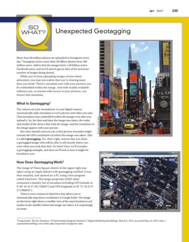
The image of Times Square shown in the upper right was
taken using an Apple Iphone with geotagging enabled. It was
then emailed, and opened on a PC using a free program
called IrfanView. The image properties (EXIF data)
contained a laundry list of metadata including GPS latitude at
N 40° 45.41 0' (40.756833°) and GPS longitude at W 73° 59.21 0'
(73.986833°).
There is even a button in IrfanView that allows you to
automatically map these coordinates to Google Earth. The image
on the lower right shows a satellite view of the exact location (a red
marker in the middle) where this image was taken. It is surprisingly
accurate.
4
Craig Smith, “By the Numbers: 70 Interesting Instagram Statistics,” Digital Marketing Ramblings, March 6, 2014, accessed May 23, 2014, http://
expandedramblings.com/index.php/important-instagram-stats.