
Page 11 - COBH EDITION 17TH MAY DIGITAL VERSION
P. 11
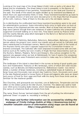
Looking at the local map of the Great Island (Cobh) tells us quite a bit about the
    island and its inhabitants. The Great Island is and is presently, in the Barony of
    Imokilly. It is comprised of two parishes, Templerobin to the west and Clonmel to
    the east. The lands of the island are again divided up by townland boundaries of
    which there are approximately thirty in total. These townland boundaries go back to
    the old Gaelic division of land and were devised prior to the Anglo Norman Invasion
    of the 12th. Century. Many of them to this day carry the old Gaelic names.

    In re distributing the confiscated land these townland boundaries were to be used
    for administrative purposes. Some interesting facts come to light when we look at
    the names of the disposed and the new owners. Most of those that lost their hold-
    ings were Catholic though there are instances of some Catholics who presumably
    supported Cromwell holding on to their title. Fota Island owned by Francis Smith
    and the nearby Belvelly area which belonged to the Barry’s or Barrymore family
    remained unchanged.

    The townlands of Ballintra, Ballydulea, Ballymore, Ballywilliam, Ballyleary, and Kil-
    garvan where the present town centre now stands were all owned by Catholics and
    were redistributed to Protestant owners, Marino and Cuskinny both in the hands of
    the Roynane family who also it appears supported the Cromwellian invasion re-
    mained unchanged. The Catholics who were disposed included some with old Irish
    names such as Mc Carthy but were mostly of Anglo Norman descendantcy such as
    the Roche’s, Walters, Meade’s, Terry’s and Duleay’s. One curious exception to the
    general rule appears when we look at Ballybrassil, for here it seems the occupying
    Walters family who were Protestant were evicted to make way for a Catholic David
    Barry.

    The landscape of the island is described in the survey as being of good quality pas-
    ture and meadowland. Features on the landscape, some of which still exist include
    castles, such as Belvelly and Ballymacshaneroe, Walterstown Castle- now demol-
    ished, a number of large residences, including a castellated house at Cuskinny, a
    large house and Dovecoate near present day Cuskinny Court, Dovecoats were used
    in the late Medieval period to house flocks of doves and pigeons who were an impor-
    tant source of food for their eggs and flesh with the dung from these birds used as
    fertilizer for the medieval garden.

    Two Churches, and graveyards are recorded, one at Ballymore, Templerobin and the
    other on the Glebe Lands at the Old Church, Clonmel. The island was said to hold
    over 2500 acres including Spike Island, which interestingly was at the time held in
    the name of a Dominick Roch and others from Cork.
    The name ‘Down Survey’ derived simply from the act of putting the information
    gathered ‘Down’ on paper ie. recording or writing it.

      The maps and further information can be accessed by visiting the
       webpage of Trinity College Dublin at http://downsurvey.tcd.ie/
     Another valuable source of information using maps can be found at
                              http://map.geohive.ie/