
Page 6 - Martello Tower No.24
P. 6
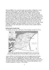
Although British army planners could not be certain of Napoleon's exact
               choice of invasion beach, they could make reasonable deductions,
               knowing the geographic and estimating the logistic limitations within
               which the French general staff would have to work. An invasion fleet
               needed to land on shallow beaches adjacent to low ground; once ashore,
               the troops would have to capture a port to bring in heavy supplies such as
               an artillery train and would require access to rich countryside capable of
               feeding an army. Within the necessary short sailing-time from France, the
               low-lying beaches between Sandgate and Eastbourne seemed the most
               probable targets for an invasion, followed by a French encirclement of
               Dover and the capture of its vital harbour. Further to the north, the coasts
               of Essex and Suffolk, although suitable for an army intent on London,
               were felt to be less vulnerable if only because of their greater distance
               from France.


               Defending the South Coast
               The British government, well aware of the strategic importance of this


                    The low-lying coast between Hythe and Winchelsea. Much of the marshland
                   has been systematically drained. The Royal Military Canal was begun in 1804


                region of Kent and East Sussex, had been strengthening its defences
                since 1793. At Dover, among other works the medieval castle was
                modernised and given additional gun batteries and a vast fortress was
                started on Western Heights opposite it. These fortifications were not just
                to protect harbour and town; they could accommodate sufficient extra
                troops to oppose an invasion in the vicinity.

                                                            6