
Page 186 - California Diving and Surfing
P. 186
122 40'W 122 30'W 122 20'W 122 10'W 122 00'W 121 50'W
M LTurkey Vulture Bonny Doon Beach 1 Wilder Ranch SANTA CRUZ 1 Franko's
OSS ANDING & Yellowbank Beach State Park New APTOS
MONTEREY
ELKHORN SLOUGH 6.4 mi. Point Reyes Laguna Creek Beach CAPITOLA Brighton Rio
Nat'l Seashore Red White & Blue Beach St. Beach Del Mar Adventure & Dive Guide
Point Reyes San Pablo Point CSoawntelalCBreuazch Beach
Bay Seacliff State Beach Hidden Beach Side 2
Red-tailed Hawk Continen6t0a0l' depth CapiStCaoSOaSlnM&aappCHutnPuaaoiMnBBottlnrloaeneoCocoSiClaapyroacareClusicraeirarCpufazdFhrnufboanriswzBBsevrlL-hiaLKeeeaSgWPiaalamkenhkoghccyegtiahhaonBBBlorWtl&feeenBChaaareBacccaahhherffcatPhcHaharkrbor Details of Monterey Bay
from Santa Cruz to Big Sur
Rules & Regulations for Low-Impact Paddling: 6.0 mi. Directions to Kirby Park: Gulf of the SLAUGHTERHOUSE REEF 60'-85' Boat Long Marine plus Monterey Harbor,
Launch and land at designated sites only. On Hwy 1, go 4.3 mi. north of Moss Landing, Elkhorn Slough, and the
Slough is day-use only. Farallones dive to rocky reef full osnf ainpvpeerrt,eabnradtecas,bezonN.aStutarateLl aBBbreioadrcgahetsoMrayrkLiAgbhbthototuMseem. Monterey Bay National Marine Sanctuary
Do not step on the marsh or mudflats. and turn right onto Salinas Rd, Nat'l Marine Duxbury Point scallops, lingcod, red
Leave nothing behind (zero trash). Go 1.2 mi. to Werner Rd, and turn right, Shelf Sanctuary Gulf of the Farallones
Go 0.2 mi. to Ekhorn Rd, and turn right, Nat'l Marine Sanctuary
Go 0.8 mi. to a fork in the road and stay right, Farallon Islands Point Bonita Lundbough
Go 2.3 mi. to Kirby Park. Visitor Center Beach
The park has free parking and a boat launch. SAN POINT SANTA CRUZ 20'-70' Rocky kelp forest with Manresa
FRANCISCO good visibility. Many nudibranchs, anemones, big State Beach
sunflower stars, cabezon, lingcod, and halibut.
Paddle in open areas only. 5.0 mi. San
Belted Francisco Lighthouse Field State Beach
Kingfisher Bay & Surfing Museum
Do not disturb wildlife-Elkhorn Slough is part Point San Pedro
of Monterey Bay National Marine Sanctuary. 1 ANI'S REEF 50'-70' Boat dive to a rocky reef
Kirby Park Elkhorn Rd Fitzgerald Marine Reserve with a beautiful covering of strawberry anemones,
1 plus scallops, lingcod, and cabezon.
Protect the natural resources. 0 1/2 Boat Launch Pillar Point
Miles 4.25 mi. Half Moon Bay Sunset
1/2 4.0 mi. State Beach
No collecting. 0 Great
Kilometers Blue
SCALE Heron Water Temp. SAN JOSE SOUTH ROCK 85'-110' Boat dive to a deep pinnacle SEACLIFF BEACH 5'-35' Beach entry to a
50-55OF (9-12OC) and large rocks full of kelp forest creatures including sandy area with generally poor visibility,
scallops, big lingcod, bat rays, cabezon, and rockfish. but hunters enjoy this dive for the halibut,
Striped Pescadero State Beach cojo salmon, and steelhead. Divers also see
Skunk Sensitive Area: The slough is important to bocaccio, surfperch, topsmelt, skates, sand
the survival of sea otters, harbor seals, and sole, and starry flounder.
birds, which are feeding and resting here. Pigeon Point Light Station State Hist. Park CAPITOLA PIER 25'-65' Boat dive to reefs one Palm Beach
It is critical that we do not disturb them. mile offshore. The bottom around the reefs is sandy,
Coyote Please keep a respectful distance (100' or Red-winged Choo Choo Tracks but kelp rises off the rocks. Gamefish abound, plus
at least eight boat lengths). Blackbird sheep crabs and abalone.
Point Año Nuevo
Año Nuevo State Reserve SANTA
Wilder Ranch State Park CRUZ
Wood Duck Raccoon Long Marine Laboratory
3.0 mi.
Common Egret 1 Monterey Bay Soquel Point
Least Tern Elkhorn Slough National Marine
Water shown at low tide mark. Caspian Tern Visitor Center Elkhorn Slough Zmudowski State Beach
Mudflat indicates high tide mark. Sanctuary Monterey Bay Nat'l Estuarine Moss Landing
Bennett Slough Prevailing Wind & Trails Information: Wildlife Area
(831) 647-4201, or
www.montereybay.noaa.gov Moss Landing State Beach Elkhorn Slough
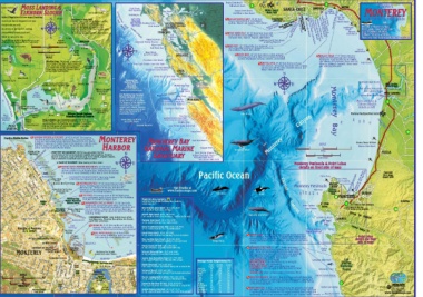
The Monterey Bay National Moss Landing Harbor
Marine Sanctuary consists MOSS LANDING
of 5,322 sq miles of ocean
along 300 miles of coastline. Salinas River State Beach
The purpose of the sanctuary Marina Research Reserve Salinas River
is to protect the ocean's
Moss Tidal Osprey natural and cultural features Monterey Canyon State Beach Monterey Bay
Wetland while allowing people to use Point Pinos Monterey
Paul's (no entry) and enjoy the ocean in a
Island Marsh 2.5 mi. sustainable way. State Beach
Landing
30' Rubis Creek Asilomar State Beach MONTEREY Moss Landing &
Carmel River State Beach Elkhorn Slough 1
Elkhorn Skimmer Barn details at left
Yacht Club Kayak Connection Point Lobos State Reserve
State CMhaonnnetel rPEeoylkwBheaoryTruKBnraanysSiainlnkogugh 1.0 mi. 2.0 mi. Garrapata State Park
Plant Plover
Moss Beach Inner Channel No boats, canoes, Blue Whale Monterey Bay Equestrian Center
or kayaks beyond
Landing Dairy Elkhorn Slough National RR Bridge Point Sur Canyon
Estuarine Research Reserve Andrew Molera State Park
Pfeiffer Big Sur State Park
Harbor Entrance Old MOSS LANDING and ELKHORN SLOUGH This historic Water Temp. 34OF (1OC) 3000'
60' Salinas R. fishing village is the gateway to California's second largest at 12,000' Depth Pfeiffer Point 600'
marine wetlands. The wetlands host sea otters, harbor seals, 300'
MOSS and over 200 species of migratory birds. It is a kayaking Shepard Meander Julia Pfeiffer Burns State Park 240'
180'
LANDING and bird-watching paradise. 120'
60'
Lopez Point 183
Hopkins Marine Station HOPKINS RESERVE & DEEP REEF 10'-40' & 60'-90' This beach or MONTEREY MONTEREY BAY Cape San Martin 6000M' onterey
boat dive is within the marine studies refuge. "Big Granite Deep" is
a boat dive that features white anemones and wolf eels. The reserve Marina Dunes RV Park
boundary is from 3rd St, Pacific Grove to the aquarium, from the mean Marina State Beach
HARBORFriSeenadsOtRotefesetrrhvee Boundary SCALE
Ocean View Kelp high tide mark to 60' depth. No marine life may be take without a N MATIONAL ARINE Ragged Point 0 24 6 8
permit issued by Hopkins Marine Station.
Miles
Humpback Whale 02468
1st St SloatBAlve MONTEREY BAY AQUARIUM World-class aquarium inspires SANCTUARY Point Piedras Blancas Kilometers MARINA
Ave conservation of the oceans through exhibits and programs. Features Fort Ord
include a fabulous, huge California kelp forest exhibit, jellyfish exhibits, William Randolph Hearst Monterey Peninsula & Point Lobos (U.S. Army,
and a wonderful oceanfront view of wild sea otters. Memorial State Beach details on front side of map
60' 30' 18'Lighthouse San Simeon State Park closed 1994)
Rocky ReefsAve To Salinas
Aquarium Reef A TASTE OF MONTEREY Wine tasting visitors center.
CenEtrvaalnAsvAevCe annerWyavRe oSwtFoLaiAmgrchHhSteathrwPoSitLnuthaeosinrSeBneteeSlSAdpStevteOnneacSketSr tSt 68
1st St Point Alones McABEE BEACH (MEXICAN RESTAURANT) 10'-50' Beach
SS GIPSY dive into a kelp forest filled with colorful invertebrates. Small Fabulous Guides
abalone survive in cracks despite otters. Wolf eels cruise around of Favorite Places
P Copyright 2011
Franko Maps, Ltd.
EaDradvliedyAve P Kelp the sunken SS Gipsy steamship (1905). Near El Torito Restaurant. Pacific Ocean MWoinnMtdeoronetwyeroBeneytaShctehatBPeaaryBkePaacrhk
Irving www.frankosmaps.com
McAbee Beach DOC RICKETTS MARINE RESERVE San Carlos Beach Point Pinos
Bay Bikes to Monterey Bay Aquarium, to a depth of 60'. 60' Lover's Point
120'
Ave (rentals) MERTRIDIUM FIELD 50'-60' Swim from San Carlos Sardines 180' Point Cabrillo
Bamboo Reef Dive Shop 240'
300' PACIFIC
600' GROVE
3000'
Carmel
Beach, following pipes north of the entry to a big 3' Visit Franko at Monterey Peninsula
diameter pipe. Follow it to the end, and then 50' www.frankosmaps.com
Prescott Ave Adventures by the Sea beyond to sa hale outcropping that has abundant large Veterans
(kayak and bike white plumed mertridium anemones. Monterey Area Camping Point Joe Memorial
rentals) California State Parks Camping Reservations:
THE PIPES Old cannery pipes at 15'-40' depth serve (800) 444-7275 Pilot Whale Orca Park SEASIDE
New Brighton State Beach (831) 464-6330
Kelp Monterey Bay as an underwater guide to point divers to the Mertridium 4 mi. south of Santa Cruz on Hwy 1 68 MONTEREY
Marine Sanctuary Field just 50' beyond the biggest pipe.
Hoffman Ave McClellan Ave Scholze Visitors Center BREAKWATER COVE (CG WHARF) 10'-60' San Carlos Canyon 17 Mile 1 115 miles to San Francisco
DrakDeicAkvmean Park Beach entry is a common open water check-out dive. Drive 30 miles to Big Sur,
Sandy along the wharf with sand dollars, sea pens, and Point Cypress 325 miles to Los Angeles
Ave Reeside Ave San Carlos Glenn's Aquarius II lots of anemones. Patchy reef to the west has a nice Lone Cypress
P Beach Park DCBiovoaeastSt GhLuoaapurdncPhierkineclplugwFbdIoaeSiontdHdcg.EhfBsRionhrMoegrdiaAmt,kNoawpu'nS.ardstW,esrMHhhAooaRpnsstFe.mrGealynaByssafiybsohstataiolnmindgbi,nolvaievtr,etwethbheraaalteteres,, Seacliff State Beach (831) 685-6442 Migrating Gray Whale CARMEL Sierra De Salinas
P 5 mi. south of Santa Cruz on Hwy 1, trailers & RVs only Carmel Valley
Manresa State Beach (831) 761-1795 Point Lobos
Private Bolio Rd 12 mi. south of Santa Cruz, walk-in only Carmel City Beach details one front
Santa Cruz/Monterey Bay KOA (831) 722-0551 side of mapt
Boat WHARF #2 5'-30' Dive on the east side only, 12 mi. south of Santa Cruz, RVs/tents/cabins Carmel
Moorings amongst sheep crabs, octopuses, and colorful Sunset State Beach (831) 763-7062 Bay
Bay Bikes anenomes. Harbormaster permission is required. 16 mi. south of Santa Cruz on Hwy 1, tents & trailers
Presidio of Monterey (rentals) Moss Landing State Beach (831) 649-2836 Point Lobos
(U.S. Army) DEL MONTE BEACH 10'-40' Beach dive 16 mi. north of Monterey on Hwy 1, one night only State Reserve
Artillery St Sport over a sandy bottom and shale outcroppings YANKEE POINT 60'-120'+ Boat dive to huge granite pinnacles
Vizcaino-Serra Landing Site Fishing with some kelp. Good student dive spot. ½ mile offshore from Yankee Pt. This is the exact midway point
between Southern and Northern California. Divers find chestnut
1st Brick House Marina Wharf # 2 30' Minke Whale cowries, nudibranchs, crabs, anemones, and sponges, plus ocean
California's 1st TheaStcroett St sunfish.
Light(Thuonnuesl)e AveMaritime
MONTEREY Boston Store Museum Marina Dunes RV Park (831) 384-6914 GARRAPATA STATE PARK 0'-120' + Divers have several Yankee
Pacific House P Monterey Bay Kayak 18' In city of Marina, privately owned, RVs only rocky shore entries at several locations along four miles of Point
(rentals, tours, sales, classes) Beach Veterans Memorial Park (831) 646-3865 park. These dive sites feature varied rocks, reefs, walls, Garrapata State Park
Monroe St In city of Monterey, first-come first-served lush kelp forests, all kinds of invertebrates, and gamefish. Soberanes Point
Watson St Conference Center P Monterey State Laguna Seca Recreation Area (831) 755-4899 Migrating gray whales pass nearby. Caution: Currents, Los
Larkin St 9 mi. east of Monterey on Hwy 68, RVs & tents surge and big swells prevail. Sites include: Padres
Van Buren StFranklin St PP Monterey PPenMinsoLuPnalktaeerDREeeylecErlsetMaetriooonnLTtareakeilASLvtaePAlqayuaa1rSsittusStDive Shop Saddle Mountain (831) 624-1617 Average Ocean Temperatures (oF) MILE MARKER 67 (30'-60' depth) National
AlCvaalrlaePdaPocriifSnitccipal StP Sports 4 mi. east of Carmel via Carmel Valley Rd & Schulte Rd WATERFALL BEACH (By Mile Marker 66, to 60' depth) Forest
Jefferson St Tyler St Fernwood Resort (831) 667-2422 Point Pacific Santa MOBY LING COVE (By cypress trees) 1
SCALE Washington St Center 24 mi. south of Carmel on Hwy 1, tents/cabins/RVs/store January Lobos Grove Cruz SOBERANES POINT (South end of Moby Ling Cove)
Adams St Big Sur Campground & Cabins (831) 667-2322 February 53 LOBOS ROCKS (15' high rocks in 100' deep water at Moby
1/4 Figueroa St Ball NSacvhaolSoPlloo(asUtt.gASrv.aeNdauvayte) 26 mi. south of Carmel on Hwy 1, RVs/tents/cabins March 53 53 54 Ling Cove)
Cortes St Field Ocean Ave Carmel By the River RV Park (831) 624-9329 April 53 54 54 REVERSE COVE (Hwy 1 turnout south of Soberanes Point)
Visitors Center 2nd St 5 mi. east of Carmel via Carmel Valley Rd & Schulte Rd May 52 54 54
Tennis Park Ave Andrew Molera State Park (831) 667-2315 June 51 55 55 Granite Canyon Bridge
0 1/2 Pearl St Dennis Camino Aguajito 21 mi. south of Carmel on Hwy , first-come first-served July 51 55 57 DIABOLO PINNACLES 20'-100'+ Boat dive to pinnacle with kelp, rose
the Menace 3rd St August 53 57 59 anemones, and purple hydrocorals. Fish include cabezon, lingcod, and
Miles P PaPrkearl St September 54 57 60 ocean sunfish. There are also large lion's mane jellyfish. Caution: Strong
0 1/4 1/2 Madison St Abrego St 4th St October 55 57 59 currents and boat traffic.
Post Munras Ave 5th St November 56 58 59
Kilometers OfWfiecbester St El December 55 56 57 VENTURA ROCKS 0'-120'+ Boat dive features two pinnacles that break Bixby Creek Bridge
Fremont St Encinal 6th St 54 55 55
Monterey Union San Cemetery 53 54 the surface, plus one pinnacle that tops out at 20' depth. A huge sheer wall
High School Carlos
P Cemetery is covered with colorful anemones. The craggy pinnacles have scallops and Hurricane Point
nudibranchs. White plume anemones reside in a cave. Caution: Swells, currents.