
Page 99 - SAICE book proof 2 LATEST JULY 2014
P. 99
s a i c e
NORTHERN CAPE PROVINCE
especially as the green circles are in huge contrast with ◊ From top to bottom:
the generally brown or grey landscape. ◊ Boegoeberg Dam
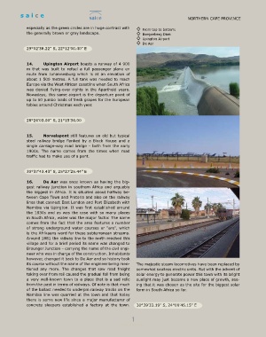
◊ Upington Airport
◊ De Aar
29°02’38.22” S, 22°12’00.40” E
14. Upington Airport boasts a runway of 4 900
m that was built to refuel a full passenger plane en
route from Johannesburg which is at an elevation of
about 1 500 metres. A full tank was needed to reach
Europe via the West African coastline when South Africa
was denied flying-over rights in the Apartheid years.
Nowadays, this same airport is the departure point of
up to 50 jumbo loads of fresh grapes for the European
tables around Christmas each year.
28°24’03.00” S, 21°15’34.00
15. Norvalspont still features an old but typical
steel railway bridge flanked by a Block House and a
single carriage-way road bridge – both from the early
1900s. The name comes from the times when road
traffic had to make use of a pont.
30°37’43.43” S, 25°27’25.44” E
16. De Aar was once known as having the big-
gest railway junction in southern Africa and arguably
the biggest in Africa. It is situated about halfway be-
tween Cape Town and Pretoria and also on the railway
lines that connect East London and Port Elizabeth with
Namibia via Upington. It was first established around
the 1830s and as was the case with so many places
in South Africa, water was the major factor. The name
comes from the fact that the area features a number
of strong underground water courses or “are”, which
is the Afrikaans word for these subterranean streams.
Around 1881 the railway line to the north reached this
village and for a brief period its name was changed to
Brounger Junction – carrying the name of the civil engi-
neer who was in charge of the construction. Inhabitants
however, changed it back to De Aar and so history took
its course without the name of the engineer being men- The majestic steam locomotives have been replaced by
tioned any more. The changes that saw road freight somewhat soulless electric units. But with the advent of
taking over from rail caused the gradual fall from being solar energy to generate power this town with its bright
a very well-known town to a place that is a sad relic sunlight may just become a new place of growth, see-
from the past in terms of railways. Of note is that much ing that it was chosen as the site for the biggest solar
of the ballast needed to underpin railway tracks on the farm in South Africa so far.
Namibia line was quarried at the town and that today
there is some new life since a major manufacturer of
concrete sleepers established a factory at the town. 30°39’33.19” S, 24°00’46.15” E
1