
Page 9 - NYS_ESS_05-2026
P. 9
issue and the depths you will survey tend to be
shallow. If you can picture this in your mind, the
Young Professionals entire system consists of the GPS receiver at the
Corner top of the range pole, the data collector clamped
Corner
Corner
to the pole as it normally would be, a length of
cable from the collector, through the processing
module (picture a 1-foot long rod extension) and
down to the transducer that screws on like a topo
CEE HydroSystems Echo Sounder boot. That’s it. The entire set up fits in a small
By Michael Lewis, LS, CFS, case and can be easily transported to any job site.
Young Professionals Committee Member The processor module performs the calculations
of the data you capture. Unlike other systems
This month we will explore the various ways a surveyor can acquire where a “smart transducer” performs the
bathymetric data in a body of water. Whether that be a lake, a pond, calculations. The data needs to be fed through
a bay, or the ocean. I use the term bathymetric somewhat lightly specific hydrographic software to post-process it
because while I have experience with some of these types of surveys, I and to perform QA/QC during the collection of
admittedly know just enough about this type of work to be dangerous! the data. Additionally, as a way of truthing the
But I’m learning more with each job I manage, thankfully with the data, it is wise to take secondary measurements,
assistance of a few colleagues that have been doing bathymetric work when possible, from the vessel by way of either
for quite some time on much larger scales than your typical NY physical measure-downs to the bed of the water
surveyor may experience. body, use of secondary GNSS receivers on lengths
The system we employ is a CEE-Line 200kHz Single Beam Echo of poles extended down, or by way of crisscross
Sounder. For the smaller types of projects we frequently take on, it is patterns when collecting the data. For instance,
the perfect set up. The entire system mounts on a standard 2-meter if you are running parallel to a channel that is to
GPS range pole. We pair it with a Leica GS16 GNSS receiver. The be dredged. Perpendicular cross sections should
unit has its own dedicated data collector, but you can also use a be run every so often to capture a different profile
tablet or a small laptop depending on what kind of software you will of the channel.
be using to QA/QC the data it is collecting and how you want to We have employed this system for various projects
display it. For most of the work we do, we have a 24’ Boston Whaler that include pre-dredge surveys, post-dredge
that has been outfitted so we can mount the range pole over the side surveys, surveys to extend landside topography
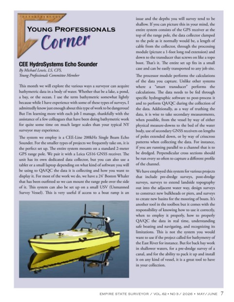
of it. This system can also be set up on a small USV (Unmanned out into the adjacent water way, design surveys
Survey Vessel). This is very useful if access to a boat ramp is an to construct new bulkheads or piers, and surveys
to create new basins for the mooring of boats. It’s
another tool in the toolbox but it comes with the
responsibility of knowing how to use it correctly,
when to employ it properly, how to properly
QA/QC the data in real time, understanding
safe boating and navigating, and recognizing its
limitations. This is not the system you would
want to use if the project called for bathymetry of
the East River for instance. But for back bay work
in shallower waters, for a pre-dredge survey of a
canal, and for the ability to pack it up and install
it on any kind of vessel, it is a great tool to have
in your collection.
EMPIRE STATE SURVEYOR / VOL. 62 • NO 3 / 2026 • MAY/JUNE 7