
Page 13 - New Wave Media - Services Brochure Winter/Spring 2018
P. 13
13
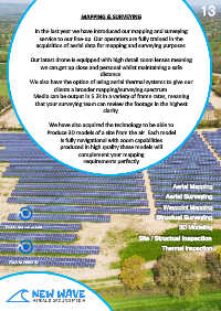
MAPPING & SURVEYING
In the last year we have introduced our mapping and surveying
service to our line-up. Our operators are fully trained in the
acquisition of aerial data for mapping and surveying purposes.
Our latest drone is equipped with high detail zoom lenses meaning
we can get up close and personal whilst maintaining a safe
distance.
We also have the option of using aerial thermal systems to give our
clients a broader mapping/surveying spectrum.
Media can be output in 5.2k in a variety of frame rates, meaning
that your surveying team can review the footage in the highest
clarity.
We have also acquired the technology to be able to
Produce 3D models of a site from the air. Each model
Is fully navigational with zoom capabilities
produced in high quality these models will
complement your mapping
requirements perfectly
Aerial Mapping
Aerial Surveying
Waypoint Mapping
Structual Surveying
3D Modeling
Site / Structual Inspection
Thermal inspection
3