Page 344 - A Hand Book of Arabia Vol 2_Neat
P. 344
!
(
\
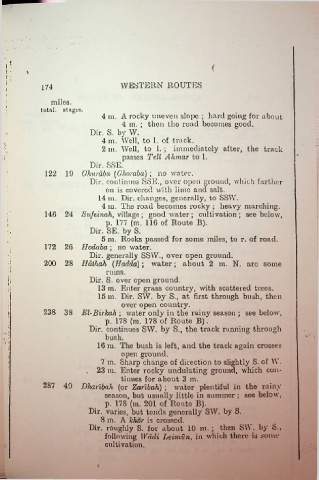
174 WESTERN ROUTES
miles.
total, stages.
4 m. A rocky uneven slope ; hard going for about
4 in. ; then the road becomes good.
Dir. S. by W.
4 m. Well, to 1. of track.
2 m. Well, to 1. ; immediately after, the track
passes Tell Ahmar to 1.
Dir. SSE.
122 19 Ghurdba (Ghoraba) ; no water.
Dir. continues SSE., over open ground, which farther
on is covered with lime and salt.
14 m. Dir. changes, generally, to SSW.
4 m. The road becomes rocky ; heavy marching.
146 24 Sufeinah, village ; good water ; cultivation ; see below,
:
p. 177 (m. 116 of Route B).
Dir. SE. by S.
5 m. Rocks passed for some miles, to r. of road,
172 26 Hodaba ; no water.
Dir. generally SSW., over open ground.
200 28 Hdthah (Haclda) ; water; about 2 m. N. are some
rums.
Dir. S. over open ground.
;;
13 m. Enter grass country, with scattered trees.
15 m. Dir. SW. by S., at first through bush, then
over open country.
238 38 El-Birkah ; water only in the rainy season ; see below,
■
p. 178 (m. 178 of Route B).
Dir. continues SW. by S., the track running through
?-\ bush.
16 m. The bush is left, and the track again crosses
open ground.
7 m. Sharp change of direction to slightly S. of AY.
. 23 m. Enter rocky undulating ground, which con
i tinues for about 3 m.
287 49 Dharibah (or Zarlbah) ; water plentiful in the rainy
season, but usually little in summer ; see below,
p. 178 (m. 201 of Route B).
Dir. varies, but tends generally SW. by S.
S m. A Ichor is crossed.
Dir. roughly S. for about 10 m. ; then SW. by S.,
following Wadi Leimun, in which there is some
cultivation.

