Page 468 - A Hand Book of Arabia Vol 2_Neat
P. 468
i


                        : ;
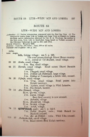
                  ROUTE 53 : LITH—WADI ‘AIN AND LOHEIA 237


                                          ROUTE 53

                           LITH—WADI ‘AIN AND LOHEIA

    i
         Authorities: (1) Native information, compared with the Red Sea Pilot. (2) The             i
             alternative routes from Llth to Loheia and from Umm el-Khishib to Loheia
             are  from native information obtained by Col. R. A. Wauhope, the section in
             the first route, from Lith to Qunfudah, being based on Turkish accounts of            !
             the Ottoman Campaign in Asir in 1911 and 1912.
         General Direction : Roughly SSE.
         Distance : Crow-fly, 325 miles ; road, 399 or 421 miles.
         Character and Supplies : see p. 54 f.
           miles.
         total, stages.
                       Lith, fishing village ; see I, p. 123.
                                  The road passes through Dhawi Hasan country.
                                11 m. Jabrat el-‘Ud Hashim, small village.
           23 23 Matla, small village.
                              9 m. Raq, small village.
            44  21 Hamdh, small village. Road enters Dhawi Barakat
                                country.
                              5 m. Theyyah, small village.
                              2  m. Dokhat esh-Shamlyah, large village.

                              5 m. Dokhat el-Yemeniyah, a fertile wadi, crossed.
            64 20 Sifsafa, small village.
                              3  m. ‘Uruj, small village. Road passes into
                                      Zobeid territory.
                              3 m. ‘Ajelein, small village in Wadi Lahsaba.
                              5 m. Hawatimah, hamlet.
            79 15      Abu Hanash, village.
                             2i m. Qurma, village.
                              2 m. Luma, village.
                                         Beni Zeid country is now entered.
                               2 m. Rahman, village.
                             2.V m. Masha’ikh, village.
                             2.V m. Sa'dah, village.
                              2 m. ‘,4mA, village.
            •4  15 QUNFUDAH, port; see I, p. 143 f.
                               7 m. Nakhl Maqbul, wells ; Wadi Mishrif (or
                                      Mashrlf) crossed.
                               7 m. Bir ed-Dibbah : wells ; Wadi Yiba crossed.
           U1 17        Muhaghwilah, small village.
                             11 m. Road enters Beni Ya'lah territory.


 I

