
Page 6 - South Africa /Azania, History of Land Settlement
P. 6
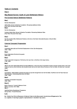
Table of. Contents

        Part 1
        Map Based Survey/ Audit of Land Settlement History

        Pre Colonial Human Settlement Patterns

        Map 1
        San/Zan Aborigenese

        Afrika Wide, Human Civilization Foundation / Pioneering Settlement Sites.
        (Plus Thirty Thousand Years Ago)
        Map 2
        San/Zan Aborigenese

        Southern Afrika Wide, Human Civilization Foundation/ Pioneering Settlement Sites
        (Plus Thirty Thousand Years Ago)

        Map 3
        San Zan and Khoi Khoi Settlements Patterns at the time of the Dutch Colonialist Invasion of South Afrika
        (6th April 1652)

        Colonial Conquest Progression

        Map 4
        Colonialists Genocide and Territorial Displacement of San/ Zan Aborigenese.
        (1652 – 1900)

        Map 5
        Dutch Colonialists Territorial Conquests
        (1652-1795)

        Map 6
        British Colonialist Conquests of Territories, that were then, to the East of the Cape Colony.
        (1795 -1848)

        Map 7
        ABantu and other Nationalities Mixed Farming Settlements, at the time when Colonialists Invaders reached; Eastern parts of the Cape
        Colony as well as other territories, that became known later as the South Africa Provinces of the Free State, the Natal and Transvaal.
        (1800)

        Map 8

        Voortrekkers / White Settlers Colonial Conquests across the Orange River into the Free State, Vaal River into the Trans-Vaal and
        UKhwahlamba / Drakensberg Mountains into Natal
        (1836 - 1848)

        Map 9
        Calendar of Colonialist Conquests.
        (1652 -1900)

        Map 10
        Native ‘Reserves’ Colonial Settlement Order
        (Native Land Acts 1913 /1936)
        Map 11

        Apartheid Native Resettlement Programme.
        (Group Areas / Forced Removals)

        N. B.
        No. Visible Foot Print of Reversal of Colonial Order by the Democratic Constitutional Dispensation Yet.
        (i.e. capable of meaningful graphic representation in standard map scale.)