
Page 26 - Bromsgrove SuDS DESIGN & EVALUATION
P. 26
6.0 Local SuDS requirements for
Local SuDS requirements
Bromsgrove
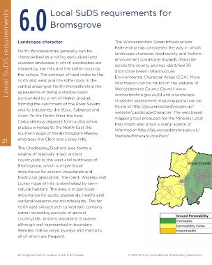
Landscape character The Worcestershire Green Infrastructure
Partnership has considered the way in which
North Worcestershire generally can be landscape character, biodiversity and historic
characterised as a rolling agricultural and environment contribute towards character
wooded landscape in which sandstones are across the county and has identified 30
marked by low hills and the softer rocks by distinctive Green Infrastructure
the valleys. The contrast of hard rocks to the Environmental Character Areas (ECA). More
north and west and the softer rock in the information can be found on the website of
central areas give North-Worcestershire the Worcestershire County Council www.
appearance of being a shallow basin worcestershire.gov.uk/GI and a landscape
surrounded by a rim of higher ground, character assessment mapping portal can be
forming the catchment of the River Severn found at http://gis.worcestershire.gov.uk/
and its tributaries, the Stour, Salwarpe and website/LandscapeCharacter. The web based
Avon. To the North-West the hard mapping tool produced for the Minerals Local
Carboniferous deposits form a distinctive Plan might also proof a useful source of
plateau whereas to the North-East the information http://gis.worcestershire.gov.uk/
southern edge of the Birmingham Plateau Website/MineralsLocalPlan/
21 embraces the Clent and Lickey Hills.
The Chaddesley/Dodford area forms a
swathe of relatively intact ancient
countryside to the west and northwest of
Bromsgrove, which is of particular
importance for ancient woodlands and
traditional grasslands. The Clent, Waseley and
Lickey ridge of hills is dominated by semi-
natural habitats. The area is of particular
importance for acidic grasslands, heaths and
wetland/watercourse microfeatures. The far
north east (Alvechurch to Wythall) contains
some interesting pockets of ancient
countryside. Ancient woodland is sparse,
although well represented in boundary
features, hollow ways, byways and marl pits,
all of which are frequent.
Bromsgrove District Council SuDS D & E Guide © 2018 McCloy Consulting & Robert Bray Associates