
Page 22 - Christie's London China Trade Paintings Kelton Collection
P. 22
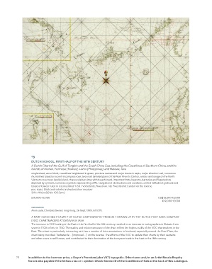
*8
                   DUTCH SCHOOL, FIRST HALF OF THE 18TH CENTURY
                   A Dutch Chart of the Gulf of Tongkin and the South China Sea, including the Coastlines of Southern China, and the
                   Islands of Hainan, Formosa [Taiwan], Luzon [Philippines], and Batavia, Java
                   single sheet, verso blank, coastlines heightened in green, province names and major towns in sepia, major islands in red, numerous
                   rhumblines based on a central compass rose, two inset detailed plans of the Pearl River to Canton, and an anchorage on the North
                   Vietnam coast near Apelle island, three scale bars (two within each inset), important forts, beacons, batteries and fag stations
                   depicted by symbols, numerous symbols representing clifs, navigational obstructions and sandbars, central latitudinal graticule and
                   tropic of Cancer ruled in red, inscribed ‘1759 / Verbeterde, Raast van / de Pracelles tot Canton’ on the reverse
                   pen, sepia, black and red inks and watercolour on paper
                   31æ x 41Ωin. (80.6 x 105.3cm.)
                   £10,000-15,000                                                         US$13,000-19,000
                                                                                            €12,000-17,000

                   PROVENANCE:
                   Anon. sale, Christie’s Swire, Hong Kong, 26 Sept. 1989, lot 1070.
                   A RARE SURVIVING EXAMPLE OF DUTCH CARTOGRAPHY PROBABLY DRAWN UP BY THE DUTCH EAST INDIA COMPANY
                   (VOC) CHARTMAKERS AT BATAVIA IN JAVA
                   The increase in VOC trading in the East in the frst half of the 18th century resulted in an increase in cartographers in Batavia from
                   seven in 1700 to forty in 1740. The quality and relative accuracy of the chart refect the highest skills of the VOC chartmakers in the
                   East. This chart is particularly interesting as it has a number of later annotations in freehand, especially around the Pearl River, the
                   chart being inscribed ‘Verbeterde ... [improved ...]’ on the reverse. The eforts of the VOC to update their charts by their captains
                   and other users is well known, and contributed to their domination of the European trade in the East in the 18th century.


          20     In addition to the hammer price, a Buyer’s Premium (plus VAT) is payable. Other taxes and/or an Artist Resale Royalty
                 fee are also payable if the lot has a tax or λ symbol. Check Section D of the Conditions of Sale at the back of this catalogue.