
Page 39 - Art In The Age Of Exploration (Great Section on Chinese Art Ming Dynasty)
P. 39
observed on the altitude marked on the gradua- 36 based on the altitude (or zenithal distances) of
tion of the instrument. Since it was not always the sun at its meridian transit (the moment
possible to observe the polestar's meridian 3»,5 , 35>5 when it reaches its highest point in the sky).
transit—sometimes, for example, clouds dark- These frequently appeared in treatises dealing
ened the sky at the moment of observation— with the use of the astrolabe (less frequently,
it was then noted that other positions in the the quadrant), but they were generally incom-
polestar's movement could be used. The star 40,5 37/5 plete. The authors lived in latitudes north of
appears to trace a circular movement around the Tropic of Cancer and were interested only in
the pole (the angular distance of the star to the rules of observation that applied to their own
pole was then estimated at 3° 30'). In addition situations. They did not consider the case of an
to the two transits of the meridian, the posi- observer situated between the tropics and the
tions chosen for observations corresponded to 42,5 39,5 equator, or observing the sun to the north of his
the other two main cardinal points (east and zenith. These cases were of interest to the
west) and also to the intermediate cardinal 42 maritime navigators, and so it was necessary to
points (northeast, southeast, southwest, and enlarge upon the traditional rules and then try
northwest). Of course only altitudes observed them out in practice. For this reason, Dom Joao
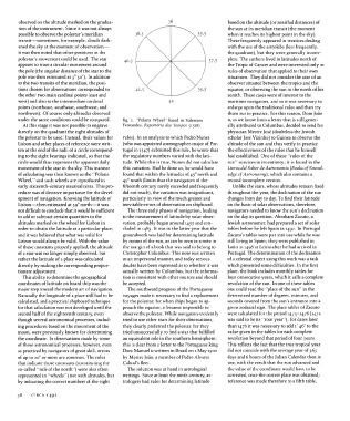
under the same conditions could be compared. fig. i. "Polaris Wheel'' based in Valentim n, as we know from a letter that is still gener-
At this stage it was not possible to engrave Fernandes, Reportorio dos Tempos (1518) ally attributed to Columbus, decided to send his
directly on the quadrant the eight altitudes of physician Mestre Jose (doubtless the Jewish
the polestar to be used. Instead, their values for rules). In an analysis to which Pedro Nunes scholar Jose Vizinho) to Guinea to observe the
Lisbon and other places of reference were writ- (who was appointed cosmographer-major of Por- altitude of the sun and thus verify in practice
ten at the end of the radii of a circle correspond- tugal in 1547) submitted this rule, he wrote that the effectiveness of the rules that he himself
ing to the eight bearings indicated, so that the the regulatory numbers varied with the lati- had established. One of these "rules of the
circle would thus represent the apparent daily tude. While this is true, Nunes did not calculate sun" survives in its entirety; it is found in the
movement of the star in the sky. This manner this variation. Had he done so, he would have Livros del Saber de Astronomia (Books of Knowl-
of calculating was then known as the "Polaris found that within the latitudes of 45° north and edge of Astronomy), which also contains a
Wheel/' and such wheels are reproduced in 45° south (limits that the navigators of the second incomplete version.
early sixteenth-century nautical texts. This pro- fifteenth century rarely exceeded and frequently Unlike the stars, whose altitudes remain fixed
cedure was of decisive importance for the devel- did not reach), the variation was insignificant, throughout the year, the declination of the sun
opment of navigation. Knowing the latitude of particularly in view of the much greater and changes from day to day. To find their latitude
Lisbon—then estimated at 39° north—it was inevitable errors of observation on shipboard. on the basis of solar observations, therefore,
not difficult to conclude that it would be sufficient The three early phases of navigation, leading navigators needed to know the sun's declination
to add or subtract certain quantities to the to the measurement of latitude by solar obser- on the day in question. Abraham Zacuto, a
altitudes marked on the wheel for Lisbon in vation, probably began around 1455 and con- Jewish astronomer, had prepared a set of solar
order to obtain the latitude at a particular place; cluded in 1485. It was in the latter year that the tables before he left Spain in 1492. In Portugal
and it was believed that what was valid for groundwork was laid for determining latitude Zacuto's tables were put into use while he was
Lisbon would always be valid. With the value by means of the sun, as can be seen in a note in still living in Spain; they were published in
of these constants properly applied, the altitude the margin of a book that was said to belong to Latin in 1496 at Leiria after he had arrived in
of a star was no longer simply observed, but Christopher Columbus. This note was written Portugal. The determination of the declination
rather the latitude of a place was calculated in an impersonal manner, and today serious of a celestial object using this work was a task
directly by making the corresponding propor- doubts have been expressed as to whether it was which presented some difficulties. In the first
tionate adjustment. actually written by Columbus, but the informa- place, the book includes monthly tables for
This ability to determine the geographical tion is consistent with other sources and should four consecutive years, which it calls a complete
coordinates of latitude on board ship was the be accepted. revolution of the sun. In one of these tables
major step toward the modern art of navigation. The southward progress of the Portuguese one could read the "place of the sun" in the
Naturally the longitude of a place still had to be voyages made it necessary to find a replacement determined number of degrees, minutes, and
calculated, and a practical shipboard technique for the polestar, for when ships began to ap- seconds covered from the sun's entrance into a
for that calculation was not developed until the proach the equator, it became impossible to given zodaical sign. The place tables of Zacuto
second half of the eighteenth century, even observe the polestar. While navigators evidently were calculated for the period 1473-1476 (1472
though several astronomical processes, includ- tried to use other stars for their observations, was said to be its "root year"); for dates later
ing procedures based on the movement of the they clearly preferred the polestar, for they than 1476 it was necessary to add i' 46" to the
moon, were previously known for determining tried unsuccessfully to find a star that fulfilled value given in the tables for each complete
the coordinate. In observations made by some an equivalent role in the southern hemisphere; revolution beyond that period of four years.
of these astronomical processes, however, even this is clear from a letter to the Portuguese king This reflects the fact that the true tropical year
as practiced by navigators of great skill, errors Dom Manuel n written in Brazil on i May 1500 did not coincide with the average year of 365
of up to 20° or more are common. The rules by Mestre Joao, a member of Pedro Alvares days and 6 hours of the Julian Calendar then in
that indicate those constants (constituting the Cabral's fleet. use, with the result that the sun advanced and
so-called "rule of the north") were also often The solution was at hand in astrological the value of the coordinate would have to be
represented in "wheels" (not with altitudes, but writings. Since at least the ninth century, as- corrected, once the correct place was obtained;
by indicating the correct numbers of the eight trologers had rules for determining latitude reference was made therefore to a fifth table,
38 CIRCA 1492