
Page 116 - Walks In The Black Range
P. 116
25. South of Percha Box
The geologic ramble described here was for the purpose of gathering information on the Fusselman Dolomite (“Sf”) Formation which overlooks the Percha Box. On the map to the right, the walk to the “Sf” site is shown as a white line, starting at the culverts under NM-152, east of Hillsboro. The walk follows Warm Springs Wash to Percha Creek and then down stream to the entrance to the Percha Box. At that point the route turns southeast up a well defined wash and then uphill (first southeast and then northeast).
Along the way there were stops at a “Mlv” (Lake Valley Limestone) geologic unit, a deposit of “Dp” (Percha Shale), a “Tvs” geologic unit (volcaniclastic deposit from the Oligocene), and finally the Fusselman Dolomite (“Sf”) unit on the top of the hills. And a bit of blooming cactus, in this case Claret Cup growing on the top of an Mlv outcrop (shown on the map above) - photo right.
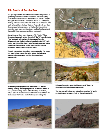
There is a great deal of geology along this walk. The photo key map, below, shows the point where the following photographs were taken and the direction of the photograph.
In the first photograph below, taken from “A”, we are looking back up Warm Springs Wash, in the area where it has opened back up. “Om” is the Montoya Formation, “Oep” is the El Paso Formation, “LPzkf” is karst fill from the Cretaceous, “Tsf” is the Santa Fe Group predating the
Palomas Formation from the Miocene, and “Qayr” is alluvium (middle Holocene to present).
The photograph below was taken from location “B” and is of the Western Boundary Fault of the Animas Uplift.
