
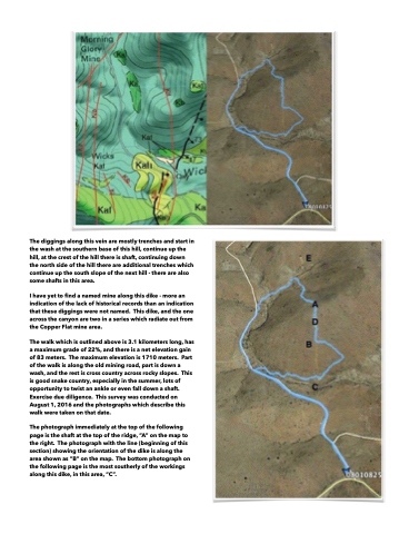
Page 76 - Walks In The Black Range
P. 76
  The diggings along this vein are mostly trenches and start in the wash at the southern base of this hill, continue up the hill, at the crest of the hill there is shaft, continuing down the north side of the hill there are additional trenches which continue up the south slope of the next hill - there are also some shafts in this area.
I have yet to find a named mine along this dike - more an indication of the lack of historical records than an indication that these diggings were not named. This dike, and the one across the canyon are two in a series which radiate out from the Copper Flat mine area.
The walk which is outlined above is 3.1 kilometers long, has a maximum grade of 22%, and there is a net elevation gain of 83 meters. The maximum elevation is 1710 meters. Part of the walk is along the old mining road, part is down a wash, and the rest is cross country across rocky slopes. This is good snake country, especially in the summer, lots of opportunity to twist an ankle or even fall down a shaft. Exercise due diligence. This survey was conducted on August 1, 2016 and the photographs which describe this walk were taken on that date.
The photograph immediately at the top of the following page is the shaft at the top of the ridge, “A” on the map to the right. The photograph with the line (beginning of this section) showing the orientation of the dike is along the area shown as “B” on the map. The bottom photograph on the following page is the most southerly of the workings along this dike, in this area, “C”.
