
Page 120 - Vol. 1 Walks In The Black Range - 2nd Edition
P. 120
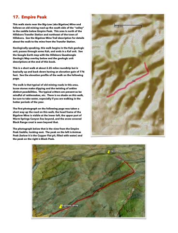
  17. Empire Peak
This walk starts near the Big-Low (aka Bigelow) Mine and follows an old mining road up the south side of the “valley” to the saddle below Empire Peak. This area is north of the Hillsboro Transfer Station and northeast of the town of Hillsboro. See the Bigelow Mine Trail description for details about the walk to the mine from the Transfer Station.
Geologically speaking, this walk begins in the Kab geologic unit, passes through some Kah, and ends in a Kaf unit. See the Google Earth map with the Hillsboro Quadrangle Geologic Map overlay below and the geologic unit descriptions at the end of this book.
This is a short walk at about 2.25 miles roundtrip but is basically up and back down having an elevation gain of 776 feet. See the elevation profile of the walk on the following page.
The walk is that typical of old mining roads in this area, loose stones make slipping and the twisting of ankles distinct possibilities. The typical critters are present so be mindful of rattlesnakes, etc. There is no shade on this walk, be sure to take water, especially if you are walking in the hotter periods of the year.
The first photograph on the following page was taken a short way up the road on this walk, the head frame of the Bigelow Mine is visible at the lower left, the upper part of Warm Springs Canyon lies beyond, and the snow covered Black Range crest is seen beyond that.
The photograph below that is the view from the Empire Peak Saddle, looking east. The peak on the left is Animas Peak (below it is the Copper Flat pit, filled with water) and the peak on the right is Black Peak.
