
Page 31 - Walks In The Black Range, Vol. 4
P. 31
South Percha Spring
There are a number of ways to reach this spring, all start at NM 152, west of Kingston and east of Emory Pass. At an elevation of 7,260 on NM-152 there is a pull out with an old mining road which descends to South Percha Creek where Drummond Canyon enters from the southwest. Where the road intersects the creek, turn right and follow South Percha west (uphill) until you reach a wide area in the canyon at 7,150. The Spring will be on your right (north side of the canyon). This is the simplest route to the spring. A shorter route starts at a pull out on NM 152 at 7,475’. This is the route which is shown below. There is no trail, follow the slope downhill to the creek. When returning, follow the slope uphill until you reach NM 152. This route is steep but not technical in nature.
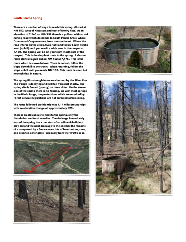
The spring fills a trough in an area burned by the Silver Fire. The trough is decaying and will fail from rust shortly. The spring site is fenced (poorly) on three sides. On the stream side of the spring there is no fencing. As with most springs in the Black Range, the protections which are required by Forest Service Regulations are not enforced at this spring.
The route followed on this trip was 1.14 miles (round-trip) with an elevation change of approximately 325’.
There is an old cabin site next to the spring, only the foundation and trash remains. The drainage immediately east of the spring has a the start of an adit which did not play out and the next drainage to the east has the remains of a camp used by a fence crew - lots of beer bottles, cans, and assorted other glass - probably from the 1950’s or so.
