
Page 80 - Walks In The Black Range, Vol. 4
P. 80
11. Cooke’s Townsite
Harley Shaw and I had been talking for some time about trying to find a disjunct population of Arizona Cypress which are said to be in the area of Cooke’s Peak. In mid- February we gathered our information and went to see if we could find the trees. Our walk is described in this entry.
This trail starts at Riley Spring (photo right) south of the Cooke’s Peak Township (ruins). The spring has been tapped and fills a cattle tank). From the spring, the route follows a good dirt road north through mine ruins of various types: unframed shafts, framed shafts (photo below), what appears to be a mill site, the remains of framed buildings, corrals, old car frames, etc..
My trail plotter was having some significant issues on this walk. The walk starts and ends at point “b” on the map (following page). The road mentioned in the previous paragraph is clearly visible. At the point where the red line of our walk finally appears (within Cooke’s Peak Township) our route followed an old road bed up hill, this quickly deteriorated to a route in a narrow and quite heavily vegetated ravine. After we reached some mine workings (photo right) we exited the ravine to the north climbing up over a ridge and eventually making it to a “good” road. We followed the road up hill until we spotted two Arizona Cypress trees, just down slope from the road. I suspect that these trees were naturally planted, even though they are growing in an area where there was a significant amount of human activity - that is entirely supposition, however, and it is entirely possible that the trees were planted by humans.
The largest cypress is actually growing on mine tailings.
We then headed back following the road down to the truck (the trail map shows two straight lines where the recorder dropped the signal, the walk followed the road which is visible on the map).
This is the general area of the Faywood Mine of the Jose or Cooks (Cooke’s) Peak Mining District. Only two minerals are listed for the Faywood Mine on mindat.org, quartz and vanadinite, there were more.
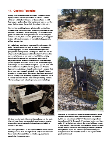
The walk, as shown in red was a little over two miles, total distance was about 3 miles, with a minimum elevation of 6,004’ and a maximum of 6,597’, the maximum grade on the walk was 20%. The grade, if you travel on the road from point “b” to the farthest point in the upper left hand corner, is very modest. The elevation profile of that part of the walk shown in red is shown on the next page - the two peaks on the right side depict the elevation profile following the straight lines on the map above and do not represent the grade on the road.
