
Page 819 - PPL-engelsk 2025
P. 819
Navigation
The gnomonic projection is only useful for finding the shortest route between
two points.
For navigation over long distances, the map is used together with the Mercator
projection.
Back to table of contents
9.4.2 Great circles and compass lines
When flying over long distances, it is important to choose the shortest route.
I was very surprised when I was on a SAS DC10 from Kastrup to Los Angeles in
1990. I thought the captain had gotten the wrong map, because instead of flying
west, or maybe west-southwest, he flew northwest.
9.4.2.1 Great circles
In theory, the shortest distance between 2 points can be found by drawing a
plane through these 2 points, and then the plane must simultaneously divide the
earth into 2 equal parts.
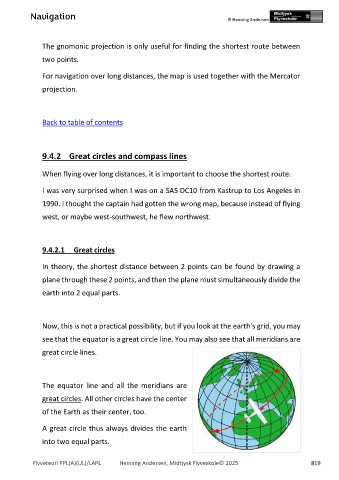
Now, this is not a practical possibility, but if you look at the earth's grid, you may
see that the equator is a great circle line. You may also see that all meridians are
great circle lines.
The equator line and all the meridians are
great circles. All other circles have the center
of the Earth as their center, too.
A great circle thus always divides the earth
into two equal parts.
Flyveteori PPL(A)(UL)/LAPL Henning Andersen, Midtjysk Flyveskole© 2025 819