
Page 235 - Green - Maritime Archaeology: A Technical Handbook. 2nd ed
P. 235
214 Maritime Archaeology: A Technical Handbook, Second Edition
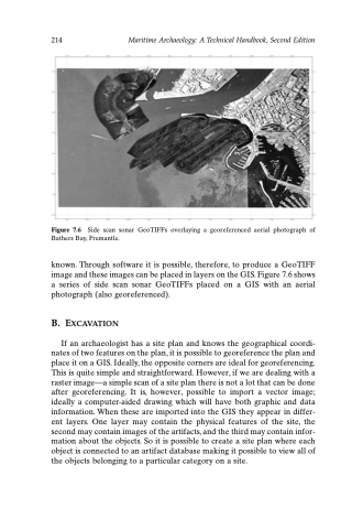
Figure 7.6 Side scan sonar GeoTIFFs overlaying a georeferenced aerial photograph of Bathers Bay, Fremantle.
known. Through software it is possible, therefore, to produce a GeoTIFF image and these images can be placed in layers on the GIS. Figure 7.6 shows a series of side scan sonar GeoTIFFs placed on a GIS with an aerial photograph (also georeferenced).
B. EXCAVATION
If an archaeologist has a site plan and knows the geographical coordi- nates of two features on the plan, it is possible to georeference the plan and place it on a GIS. Ideally, the opposite corners are ideal for georeferencing. This is quite simple and straightforward. However, if we are dealing with a raster image—a simple scan of a site plan there is not a lot that can be done after georeferencing. It is, however, possible to import a vector image; ideally a computer-aided drawing which will have both graphic and data information. When these are imported into the GIS they appear in differ- ent layers. One layer may contain the physical features of the site, the second may contain images of the artifacts, and the third may contain infor- mation about the objects. So it is possible to create a site plan where each object is connected to an artifact database making it possible to view all of the objects belonging to a particular category on a site.
