
Page 236 - Green - Maritime Archaeology: A Technical Handbook. 2nd ed
P. 236
Chapter 7: Site Plans and Geographical Information Systems 215
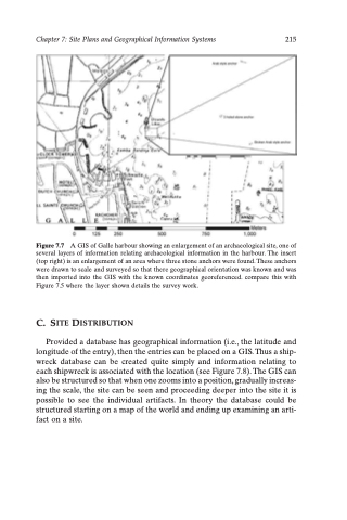
Figure 7.7 A GIS of Galle harbour showing an enlargement of an archaeological site, one of several layers of information relating archaeological information in the harbour. The insert (top right) is an enlargement of an area where three stone anchors were found. These anchors were drawn to scale and surveyed so that there geographical orientation was known and was then imported into the GIS with the known coordinates georeferenced. compare this with Figure 7.5 where the layer shown details the survey work.
C. SITE DISTRIBUTION
Provided a database has geographical information (i.e., the latitude and longitude of the entry), then the entries can be placed on a GIS. Thus a ship- wreck database can be created quite simply and information relating to each shipwreck is associated with the location (see Figure 7.8). The GIS can also be structured so that when one zooms into a position, gradually increas- ing the scale, the site can be seen and proceeding deeper into the site it is possible to see the individual artifacts. In theory the database could be structured starting on a map of the world and ending up examining an arti- fact on a site.
