
Page 54 - Green - Maritime Archaeology: A Technical Handbook. 2nd ed
P. 54
Chapter 3: Search and Survey 33
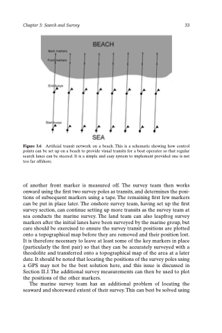
Figure 3.6 Artificial transit network on a beach. This is a schematic showing how control points can be set up on a beach to provide visual transits for a boat operator so that regular search lanes can be steered. It is a simple and easy system to implement provided one is not too far offshore.
of another front marker is measured off. The survey team then works onward using the first two survey poles as transits, and determines the posi- tions of subsequent markers using a tape. The remaining first few markers can be put in place later. The onshore survey team, having set up the first survey section, can continue setting up more transits as the survey team at sea conducts the marine survey. The land team can also leapfrog survey markers after the initial lanes have been surveyed by the marine group, but care should be exercised to ensure the survey transit positions are plotted onto a topographical map before they are removed and their position lost. It is therefore necessary to leave at least some of the key markers in place (particularly the first pair) so that they can be accurately surveyed with a theodolite and transferred onto a topographical map of the area at a later date. It should be noted that locating the positions of the survey poles using a GPS may not be the best solution here, and this issue is discussed in Section II.J. The additional survey measurements can then be used to plot the positions of the other markers.
The marine survey team has an additional problem of locating the seaward and shoreward extent of their survey. This can best be solved using
