
Page 14 - Marine Magnetometer Processing
P. 14
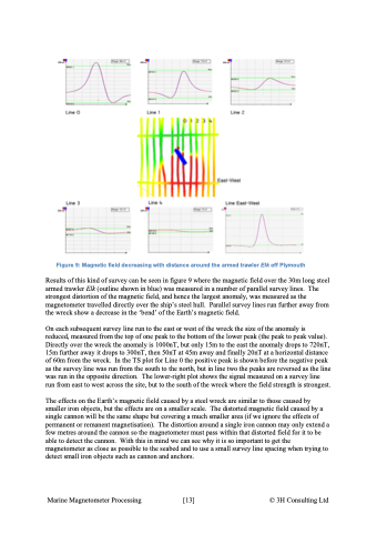
Figure 9: Magnetic field decreasing with distance around the armed trawler Elk off Plymouth Results of this kind of survey can be seen in figure 9 where the magnetic field over the 30m long steel armed trawler Elk (outline shown in blue) was measured in a number of parallel survey lines. The strongest distortion of the magnetic field, and hence the largest anomaly, was measured as the magnetometer travelled directly over the ship’s steel hull. Parallel survey lines run further away from the wreck show a decrease in the ‘bend’ of the Earth’s magnetic field. On each subsequent survey line run to the east or west of the wreck the size of the anomaly is reduced, measured from the top of one peak to the bottom of the lower peak (the peak to peak value). Directly over the wreck the anomaly is 1000nT, but only 15m to the east the anomaly drops to 720nT, 15m further away it drops to 300nT, then 50nT at 45m away and finally 20nT at a horizontal distance of 60m from the wreck. In the TS plot for Line 0 the positive peak is shown before the negative peak as the survey line was run from the south to the north, but in line two the peaks are reversed as the line was run in the opposite direction. The lower-right plot shows the signal measured on a survey line run from east to west across the site, but to the south of the wreck where the field strength is strongest. The effects on the Earth’s magnetic field caused by a steel wreck are similar to those caused by smaller iron objects, but the effects are on a smaller scale. The distorted magnetic field caused by a single cannon will be the same shape but covering a much smaller area (if we ignore the effects of permanent or remanent magnetisation). The distortion around a single iron cannon may only extend a few metres around the cannon so the magnetometer must pass within that distorted field for it to be able to detect the cannon. With this in mind we can see why it is so important to get the magnetometer as close as possible to the seabed and to use a small survey line spacing when trying to detect small iron objects such as cannon and anchors. Marine Magnetometer Processing \[13\] © 3H Consulting Ltd
