
Page 24 - Marine Magnetometer Processing
P. 24
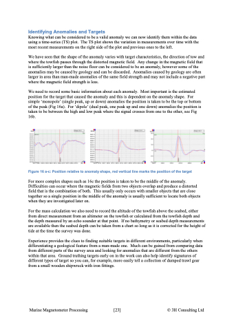
Identifying Anomalies and Targets Knowing what can be considered to be a valid anomaly we can now identify them within the data using a time-series (TS) plot. The TS plot shows the variation in measurements over time with the most recent measurements on the right side of the plot and previous ones to the left. We have seen that the shape of the anomaly varies with target characteristics, the direction of tow and where the towfish passes through the distorted magnetic field. Any change in the magnetic field that is sufficiently larger than the noise floor can be considered to be an anomaly, however some of the anomalies may be caused by geology and can be discarded. Anomalies caused by geology are often larger in area than man-made anomalies of the same field strength and may not include a negative part where the magnetic field strength is less. We need to record some basic information about each anomaly. Most important is the estimated position for the target that caused the anomaly and this is dependent on the anomaly shape. For simple ‘monopole’ (single peak, up or down) anomalies the position is taken to be the top or bottom of the peak (Fig 16a). For ‘dipole’ (dual peak, one peak up and one down) anomalies the position is taken to be between the high and low peak where the signal crosses from one to the other, see Fig 16b. Figure 16 a-c: Position relative to anomaly shape, red vertical line marks the position of the target For more complex shapes such as 16c the position is taken to be the middle of the anomaly. Difficulties can occur where the magnetic fields from two objects overlap and produce a distorted field that is the combination of both. This usually only occurs with smaller objects that are close together so a single position in the middle of the anomaly is usually sufficient to locate both objects when they are investigated later on. For the mass calculation we also need to record the altitude of the towfish above the seabed, either from direct measurement from an altimeter on the towfish or calculated from the towfish depth and the depth measured by an echo sounder at that point. If no bathymetry or seabed depth measurements are available then the seabed depth can be taken from a chart so long as it is corrected for the height of tide at the time the survey was done. Experience provides the clues to finding suitable targets in different environments, particularly when differentiating a geological feature from a man-made one. Much can be gained from comparing data from different parts of the survey area and looking for anomalies that are different from the others within that area. Ground truthing targets early on in the work can also help identify signatures of different types of target so you can, for example, more easily tell a collection of dumped trawl gear from a small wooden shipwreck with iron fittings. Marine Magnetometer Processing \[23\] © 3H Consulting Ltd
