
Page 33 - Kennemerland VOC ship, 1664 - Published Reports
P. 33
R. PFUCE & K. MUCKELROY: KENNEMERLAND
was securely established, and each find or group of finds was triangulated onto this.
Obviously, only a sample area of the whole site could be investigated in the time available. The size of the area which it was feasible to tackle was further limited by the sea-bed conditions. Before any investigation could begin, many hours had to be spent clearing the selected area of its overburden of weed, which often stood between one and two metres high. Then the area had to be cleared of large boulders as the excavation pro- ceeded; this was done with rope slings and inner tubes, the rocks being subsequently dumped away from the site. Apart from these boulders, the bottom was formed of a mixture of pebbles and gravel, up to half a metre thick in places, within which the artefacts were contained. Although detailed notes were made, where possible, on any discernable stratigraphical relationships, we are confi- dent that nothing of significance can be deduced from such information; the emphasis below is thus solely on horizontal relation- ships. In choosing the sites for excavation, it was important to strike a balance between clearing areas which would be particularly rewarding in terms of finds (and their intrinsic
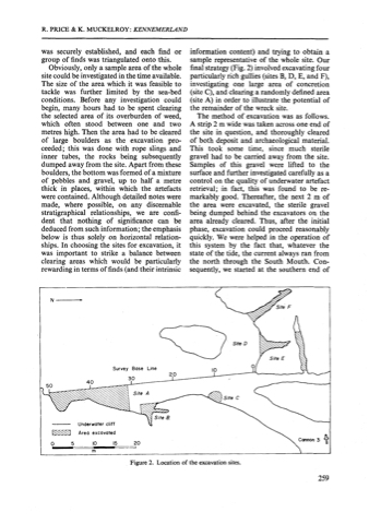
information content) and trying to obtain a sample representative of the whole site. Our final strategy (Fig. 2) involved excavating four particularly rich gullies (sites B, D, E, and F), investigating one large area of concretion (site C ) , and clearing a randomly defined area (site A) in order to illustrate the potential of the remainder of the wreck site.
The method of excavation was as follows. A strip 2 m wide was taken across one end of the site in question, and thoroughly cleared of both deposit and archaeological material. This took some time, since much sterile gravel had to be carried away from the site. Samples of this gravel were lifted to the surface and further investigated carefully as a control on the quality of underwater artefact retrieval; in fact, this was found to be re- markably good. Thereafter, the next 2 m of the area were excavated, the sterile gravel being dumped behind the excavators on the area already cleared. Thus, after the initial phase, excavation could proceed reasonably quickly. We were helped in the operation of this system by the fact that, whatever the state of the tide, the current always ran from the north through the South Mouth. Con- sequently, we started at the southern end of
Underwater cliff
Survey Base Line
Figure 2. Location of the excavation sites.
259
