
Page 35 - The ROV Manual - A User Guide for Remotely Operated Vehicles 2nd edition
P. 35
2.1 Physical oceanography 23
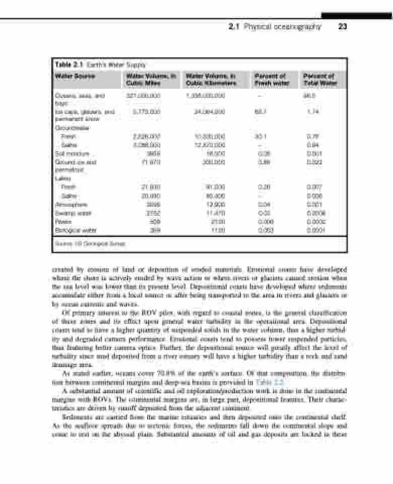
Table 2.1 Earth’s Water Supply
Water Source Water Volume, in Water Volume, in Percent of Percent of Cubic Miles Cubic Kilometers Fresh water Total Water
Oceans, seas, and bays
Ice caps, glaciers, and permanent snow Groundwater
Fresh
Saline
Soil moisture
Ground ice and permafrost Lakes
321,000,000 5,773,000
2,526,000 3,088,000 3959 71,970
1,338,000,000 24,064,000 68.7
10,530,000 30.1 12,870,000
16,500 0.05 300,000 0.86
91,000 0.26 85,400 12,900 0.04 11,470 0.03
2120 0.006 1120 0.003
96.5 1.74
0.76 0.94 0.001 0.022
0.007 0.006 0.001 0.0008 0.0002 0.0001
Fresh 21,830
Saline 20,490 Atmosphere 3095 Swamp water 2752 Rivers 509 Biological water 269
Source: US Geological Survey.
created by erosion of land or deposition of eroded materials. Erosional coasts have developed where the shore is actively eroded by wave action or where rivers or glaciers caused erosion when the sea level was lower than its present level. Depositional coasts have developed where sediments accumulate either from a local source or after being transported to the area in rivers and glaciers or by ocean currents and waves.
Of primary interest to the ROV pilot, with regard to coastal zones, is the general classification of these zones and its effect upon general water turbidity in the operational area. Depositional coasts tend to have a higher quantity of suspended solids in the water column, thus a higher turbid- ity and degraded camera performance. Erosional coasts tend to possess fewer suspended particles, thus featuring better camera optics. Further, the depositional source will greatly affect the level of turbidity since mud deposited from a river estuary will have a higher turbidity than a rock and sand drainage area.
As stated earlier, oceans cover 70.8% of the earth’s surface. Of that composition, the distribu- tion between continental margins and deep-sea basins is provided in Table 2.2.
A substantial amount of scientific and oil exploration/production work is done in the continental margins with ROVs. The continental margins are, in large part, depositional features. Their charac- teristics are driven by runoff deposited from the adjacent continent.
Sediments are carried from the marine estuaries and then deposited onto the continental shelf. As the seafloor spreads due to tectonic forces, the sediments fall down the continental slope and come to rest on the abyssal plain. Substantial amounts of oil and gas deposits are locked in these
