Page 9 - ICS Siebel 8.1 and Master Template.11.16.15_Neat
P. 9
Air Masses and Fronts

               When a body of air comes to rest on, or moves slowly over, an extensive area having fairly uniform
               properties of temperature and moisture, the air takes on these properties.  The area over which the
               air mass acquires its identifying distribution of temperature and moisture is its “source region.”
               As this air mass moves from its source region, it tends to take on the  properties of the new
               underlying surface.  The trend toward change is called air mass modification.  When an air mass
               that tis different in such properties advances upon a dissimilar air mass, the division line is referred
               to as a front.

               A ridge is an elongated area of high pressure, A trough is an elongated area of low pressure.  All
               fronts lie in troughs.  A cold front is the leading edge of an advancing cold air mass.  Cold fronts
               are often accomplished by poor weather ahead of the front, which passes relatively quickly.  Once
               the front has passed, there is a wind shift and, due to the increased wind speeds, turbulence is
               common for a period of time.  More severe could fronts can also produce thunderstorms, hail, and
               tornadoes.
               A warm front is the leading edge of an advancing war air mass.  Warm fronts move about half as
               fast as cold fronts and have more widespread impact on weather.  They are often preceded by
               lowered ceilings, increased precipitation, and reduced visibilities.  Remote PICs should be aware
               of ambient and approaching weather systems as they can significantly impact their operations and
               safety of flight.  Frontal waves and cyclones (areas of low pressure) usually form on slower-
               moving cold fronts or  stationary fronts.   These types of systems are often accompanied by
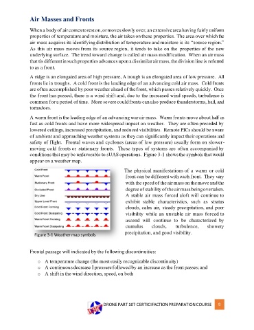
               conditions that may be unfavorable to sUAS operations.  Figure 3-1 shows the symbols that would
               appear on a weather map.

                                                             The physical manifestations of a  warm or cold
                                                              front can be different with each front.  They vary
                                                              with the speed of the air mass on the move and the
                                                              degree of stability of the air mass being overtaken.
                                                              A stable air mass forced aloft will  continue to
                                                              exhibit  stable  characteristics,  such  as  stratus
                                                              clouds, calm air, steady precipitation, and poor
                                                              visibility  while an unstable air  mass forced to
                                                              ascend  will  continue  to  be  characterized  by
                                                              cumulus     clouds,     turbulence,    showery
                                                             precipitation, and good visibility.
                  Figure 3-1 Weather map symbols


               Frontal passage will indicated by the following discontinuities:

                   o  A temperature change (the most easily recognizable discontinuity)
                   o  A continuous decrease I pressure followed by an increase as the front passes; and
                   o  A shift in the wind direction, speed, on both


                                                   DRONE PART 107 CERTICIFACTION PREPARATION COURSE       9

