
Page 14 - Tuskegee Airmen Drone License Preparatory Course Chp.2 Manual
P. 14
Topography
To identify a point on the surface of the earth, a geographic coordinate, or “grid” system was devised.
By reference to meridians of longitude and parallels of latitude, any position may be accurately located
when using the grid system.
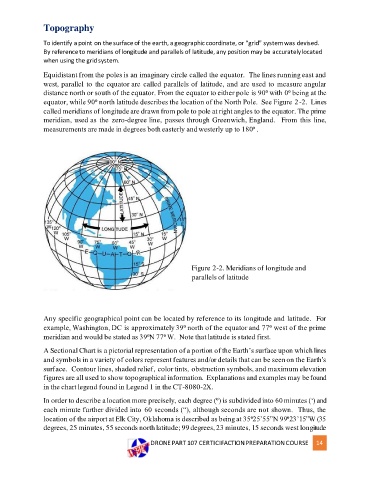
Equidistant from the poles is an imaginary circle called the equator. The lines running east and
west, parallel to the equator are called parallels of latitude, and are used to measure angular
distance north or south of the equator. From the equator to either pole is 90⁰ with 0⁰ being at the
equator, while 90⁰ north latitude describes the location of the North Pole. See Figure 2-2. Lines
called meridians of longitude are drawn from pole to pole at right angles to the equator. The prime
meridian, used as the zero-degree line, passes through Greenwich, England. From this line,
measurements are made in degrees both easterly and westerly up to 180⁰ .
Figure 2-2. Meridians of longitude and
parallels of latitude
Any specific geographical point can be located by reference to its longitude and latitude. For
example, Washington, DC is approximately 39⁰ north of the equator and 77⁰ west of the prime
meridian and would be stated as 39⁰N 77⁰ W. Note that latitude is stated first.
A Sectional Chart is a pictorial representation of a portion of the Earth’s surface upon which lines
and symbols in a variety of colors represent features and/or details that can be seen on the Earth’s
surface. Contour lines, shaded relief, color tints, obstruction symbols, and maximum elevation
figures are all used to show topographical information. Explanations and examples may be found
in the chart legend found in Legend 1 in the CT-8080-2X.
In order to describe a location more precisely, each degree (⁰) is subdivided into 60 minutes (‘) and
each minute further divided into 60 seconds (“), although seconds are not shown. Thus, the
location of the airport at Elk City, Oklahoma is described as being at 35⁰25’55”N 99⁰23’15”W (35
degrees, 25 minutes, 55 seconds north latitude; 99 degrees, 23 minutes, 15 seconds west longitude
DRONE PART 107 CERTICIFACTION PREPARATION COURSE 14