
Page 278 - House of Maxell
P. 278
258 ANTENNA BASICS
5.5.7 Synthetic Aperture Radar (SAR)
An in-depth description of SAR technology is far beyond the scope of this book since the main
accent in SAR is shifted more to sophisticated signal processing than to antenna performance.
So we refer the reader to [20 - 23] for more details and focus on fundamental principles.
From the standpoint of antenna engineers, the most significant aspect of SAR is that the SAR
antenna turns out to be an integral part of signal processing and can be significantly simplified.
We stated several times that the primary task of any antenna in a system was to emit and then
collect the as much available energy of useful signal as possible for the best recognition and
following extraction of valuable information. We have seen that the spatial signal
discrimination or steering the narrow beam to the target direction means that all antenna
elements process signals in unison. This technique can be treated as spatial and parallel signal
processing and leads from time to time to development of gargantuan antennas like the radio
telescope in Figure 5.2.5a or the radar antennas in Figure 5.5.1. Alternatively, the same amount
of information can be sent and obtained on a portion-to-portion basis, stored and then processed
to extract a complete picture of events.
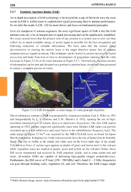
Figure 5.5.8 SAR illustration: a) radar image, b) radar principle depiction
The revolutionary concept of SAR was proposed by American scientists Carl A. Wiley in 1951
and independently by L. J. Cutrona and C.W. Sherwin in 1952, opening the era of high-
resolution imaging/vision of remote objects at microwave frequencies. The first SAR started
operating in 1952 and had improved significantly since then. Modern SAR radars can provide
resolution up to a few millimeters and much better in the submillimeter frequency band. The
24
radar image in Figure 5.5.8a was acquired by the SIR-C/X-SAR radar on board the Space
Shuttle Endeavour. It displays the Teide volcano not far from the city of Santa Cruz de Tenerife,
Spain. The city is visible as the purple and white area on the lower right edge of the island.
Volcano lava flows of various ages appears in shades of green and brown next to the volcano
while vegetation zones are marked in purple, green and yellow on the volcano's flanks. Since
EM waves transmitted and received by SAR penetrate clouds, and to some extent rain and
snow, all-weather SARs are capable of delivering high-quality images around-the-clock.
Furthermore, the EM waves of P-band (250 – 500 MHz) and L-band (1 – 2 GHz) frequencies
can pass through building walls, vegetation [1], and soil. Therefore, the SAR images might
24 Public Domain Image, source: https://commons.wikimedia.org/w/index.php?curid=117320