
Page 261 - AWSAR_1.0
P. 261
Why Floods Occurs Over Tamil Nadu Coast?
rainfall on 1 December 2015 over Chennai mentioned before in the article. The study was published by the American Meteorological Society in Monthly Weather Review.
During winter monsoon, many tropical depressions form over the Bay of Bengal and move westwards towards Indian peninsula. They give heavy rainfall over the east coast during their passage. Rainfall accumulations of 100- 200mm in a day are normal over Chennai due to these depressions. The study first identifies that the unprecedented flood over Chennai on 1 December 2015 was due to the storm-clouds being stationary over Chennai for about two days. By performing computer simulations of the event, the study proposes a mechanism by which this happens.
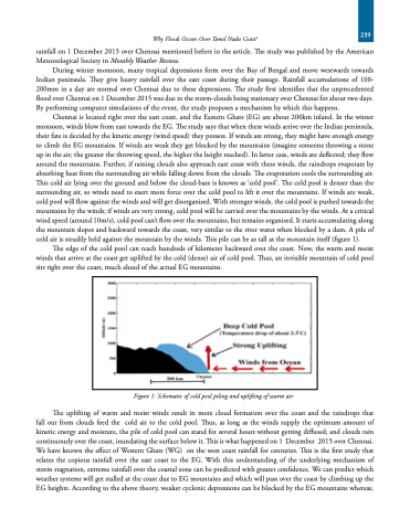
Chennai is located right over the east coast, and the Eastern Ghats (EG) are about 200km inland. In the winter monsoon, winds blow from east towards the EG. The study says that when these winds arrive over the Indian peninsula, their fate is decided by the kinetic energy (wind speed) they possess. If winds are strong, they might have enough energy to climb the EG mountains. If winds are weak they get blocked by the mountains (imagine someone throwing a stone up in the air; the greater the throwing speed, the higher the height reached). In latter case, winds are deflected; they flow around the mountains. Further, if raining clouds also approach east coast with these winds, the raindrops evaporate by absorbing heat from the surrounding air while falling down from the clouds. The evaporation cools the surrounding air. This cold air lying over the ground and below the cloud-base is known as ‘cold pool’. The cold pool is denser than the surrounding air, so winds need to exert more force over the cold pool to lift it over the mountains. If winds are weak, cold pool will flow against the winds and will get disorganised. With stronger winds, the cold pool is pushed towards the mountains by the winds; if winds are very strong, cold pool will be carried over the mountains by the winds. At a critical wind speed (around 10m/s), cold pool can’t flow over the mountains, but remains organised. It starts accumulating along the mountain slopes and backward towards the coast, very similar to the river water when blocked by a dam. A pile of cold air is steadily held against the mountain by the winds. This pile can be as tall as the mountain itself (figure 1).
The edge of the cold pool can reach hundreds of kilometer backward over the coast. Now, the warm and moist winds that arrive at the coast get uplifted by the cold (dense) air of cold pool. Thus, an invisible mountain of cold pool sits right over the coast, much ahead of the actual EG mountains.
Figure 1: Schematic of cold pool piling and uplifting of warm air
The uplifting of warm and moist winds result in more cloud formation over the coast and the raindrops that fall out from clouds feed the cold air to the cold pool. Thus, as long as the winds supply the optimum amount of kinetic energy and moisture, the pile of cold pool can stand for several hours without getting diffused; and clouds rain continuously over the coast, inundating the surface below it. This is what happened on 1 December 2015 over Chennai. We have known the effect of Western Ghats (WG) on the west coast rainfall for centuries. This is the first study that relates the copious rainfall over the east coast to the EG. With this understanding of the underlying mechanism of storm stagnation, extreme rainfall over the coastal zone can be predicted with greater confidence. We can predict which weather systems will get stalled at the coast due to EG mountains and which will pass over the coast by climbing up the EG heights. According to the above theory, weaker cyclonic depressions can be blocked by the EG mountains whereas,
239
