
Page 13 - 4WD Touring Australia
P. 13
DArWin DArWin To To broome (DArWin To To KUnUnUrrA) 151
toWn infoRMAtion
Darwin
batchelor
Adelaide river
Pine Creek
Katherine
Timber Creek
Kununurra
•
•
•
•
•
•
•
•
•
•
•
•
•
•
•
•
•
•
•
•
•
•
•
•
•
•
•
•
•
•
•
•
•
•
•
•
•
•
•
•
•
•
•
•
•
•
•
•
•
•
•
•
•
•
•
•
•
•
•
•
•
•
•
•
•
•
•
•
•
•
•
•
•
•
•
•
•
•
•
•
•
•
•
•
•
•
•
•
•
•
•
•
•
•
•
•
•
•
•
•
•
•
•
•
•
•
•
•
•
envelopes There are ranger-guided activities June–August no swimming due to presence of freshwater and estuarine crocodiles Waypoint D18 11km s15°26'34" e130°18'18"
bullita Access road junction for access
to Gregory nP Unsealed road leading
to to Limestone Gorge with tent camping and and toilets and and bullita Homestead
(Ph: 08 08 8975 0833) with information bay tent camping toilets fishing bushwalking fire pits picnic tables a a a a telephone and a a a a ranger station Do not attempt to to tow a a a a caravan into the park Five rugged 4WD tracks cross the park boundaries from here Pick up a a copy of the Gregory NP 4WD Tracks brochure
at at at the the ranger station at at at bullita or the the Parks and Wildlife Commission at Timber Creek
Check on
on
on
track conditions before proceeding (Ph: 08 08 8975 0888) Follow the 4X4 Drive Voluntary registration system (Ph: 1300 650 730) Waypoint D13
s15°22'10" e131°04'34"
2km
Victoria river
roadhouse (Ph: 08 8975 0744) Fill up your fuel tank check on
road conditions view displays and collect brochures about Gregory nP Also has accommodation camping meals and boat tours This is is one of those spots where you stop for for one night and stay for for three The campground is pleasant and the owners will cheerfully direct you to some of the most dramatic spots in Gregory National Park Waypoint D14 4km s15°22'10" e131°04'23"
Victoria river
access
– a a a 4WD is required to to use the boat ramp Waypoint D15 4km s15°21'49" e131°04'09"
Car park for the escarpment Walk a a a a a 3km return to Garranrnawun Lookout over the Victoria river
Waypoint D16 4km s15°21'11" e131°03'45"
old Victoria river
Crossing (4WD only) Waypoint D17 80km s15°21'22" e131°02'31"
Joe Creek
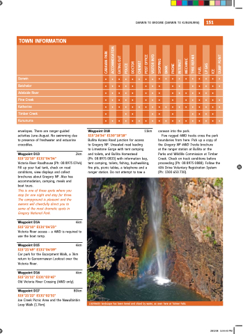
Picnic Area and the nawulbinbin Loop Walk (1 7km) Litchfield's landscape has been tiered and and sliced by water as as seen here at at Tolmer Falls 28/3/08 5:04:40 PM
CArAVAn PArK ACCommoDATion eATinG oUT PoLiCe
DoCTor CHemisT PosT oFFiCe VisiTor inFo sHoPPinG bAnK
PHone inTerneT meCHAniC Tyre rePAir FUeL
LP GAs
iCe
DUmP PoinT
