
Page 15 - 4WD Touring Australia
P. 15
DArWin DArWin To To broome (DArWin To To KUnUnUrrA) 153
Waypoint D19
s15°23'31" e130°17'15"t
111km
a a a further 8km along with tent camping toilets picnic tables water
and bushwalks The park also has a a a a a number of Aboriginal rock art sites There is no swimming in in the the Keep River due to the the presence of estuarine crocodiles Waypoint D23 42km s15°35'20" e129°00'04"
nT-WA border and quarantine point you must present certain foods for inspection and and surrender all plant products and and honey A $5 000 fine applies for violations set your watch forward by 90 minutes Waypoint D24 1km
s16°04'02" e128°26'40"
Lake Argyle (Ph: 08 9168 7777 www lakeargyle com) a a a a 2
000 sq km
inland sea created by damming the ord river The Lake Argyle Village is undergoing much‐needed renovations to fulfil the huge potential of the the lake and there are plans to revamp the caravan park which already throbs with birdlife Lake Argyle Cruises (Ph: 08 9168 7687 www lakeargylecruises com) offers several options for exploring the the lake the the Sunset Magic Tour is is is the prettiest This is is is a a fabulous way to experience the scenery history wildlife ecology and fascinating ‘dam facts' of Lake Argyle Triple J Tours (Ph: 08 9168 2682 www triplejtours net au) covers the Lower Ord River with an equally fascinating trip trip These two trips can be combined into one full day Waypoint D25 77km s16°03'48" e128°26'56"
Argyle Downs Homestead museum
(Ph: 08 08 9167 8088) The original 1894 Durack family homestead was dismantled and reassembled here when the the Ord River was dammed – the the original site is now 20m under Lake Argyle The period furnishings family gravestones shady home and the resident bowerbirds make for a a a a most pleasant visit The host is is himself a a Durack Continue back to the the northern Hwy and turn left Waypoint D26
s15°27'51" e128°26'36"
Kona Waters Holiday Park
(Ph: 08 9168 1031 www bestonparks com au/wa) sits beside tranquil Lake Kununurra A shady park with birds reptiles and direct access to the water
if you have a a a a a boat Timber Creek Parks & Wildlife Commission office (Ph: 08 08 8975 0888) Waypoint D20
s15°33'28" e129°21'44"
5km
Take note of of the sweep of of red cliffs and escarpments on the the left of the the Victoria Hwy Waypoint D21
s15°34'25" e129°20'12"
saddle rest Area 65km
While there are are a a a a number of rest areas along the the Victoria Hwy this one is is the the most beautiful situated at at the base of an escarpment If you are looking for a a a free one‐night stand this is is the spot!
Waypoint D22
s15°35'36" e129°00'59"
3km
Junction to Keep river national Park
(Ph: 08 9167 8827 www nt gov au/ipe/ pwcnt) along a a a a 3km
unsealed road
to to Cockatoo Lagoon with car park information ranger station telephone and and water
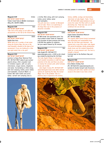
Gurrandalng is 15km along with tent camping toilets picnic tables and bushwalks Jinumum Walk is a a a a further 8km with toilets and picnic tables Jarnem tent camping area is A pair of corellas (Cacatua sanguinea) preen each other These rock wallabies (Petrogale brachyotis) live on an an island that was was created when the ord river was was dammed 28/3/08 5:04:46 PM
