
Page 5 - Pine Bluff and Jefferson County, Arkansas {1893}
P. 5
JEFFERSON COUNTY, ARK.
GENERAL HISTORY OF ARKANSAS. Washington. It has an area of square miles of 52,198;
in acres, 33,406,720. It is divided into 76 counties, and
Arkansas was discovered by Marquette in July, 1673. had, according to the census of 1870, a population of
About May i, 16S6, Henri de Tonty established the 484,471. The census of 1880 gave Arkansas a popula-
first white settlement at Arkansas Post, leaving there tion of 802,525; that of 1890, 1,128,178.
six Frenchmen. It then formed a part of the famous
Louisiana Territory, which extended to Florida on the The Arkansas river, taking its rise in the Rocky
east, Texas on the west, the Gulf of Mexico on the Mountains of Colorado, flows in a southeasterly course
south, and what is now the Dominion of Canada on the a distance of 2,000 miles to the Mississippi river; it
north. In 1S03, Napoleon Bonaparte, fearing its loss passes diagonally through the State, and it, with the
to England, ceded this immense region to the United White, Red, Black, Wachita, Saline and other rivers,
affords navigable highways in the State of over 3,500
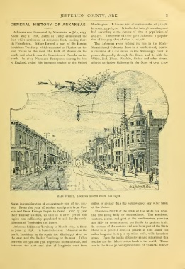
MAIN STREET, LOOKING SOUTH FROM BARRAQUE
States in consideration of an aggregate sum of $15,000,- miles, or greater than the waterways of any other State
000. From the year of cession immigrants from Can-
ada and from Europe began to come. Year by year of the Union.
their number swelled, so that in a brief period this
region was sufficiently populated to call for the estab- About one-fourth of the lands of the State are level,
lishment of Territories and States. the rest being hilly or mountainous. The northern,
western, central and part of the southwestern countie*
Arkansas became a Territory in March 1S19, a State
on June 15, 1S36. Its boundaries are: Missouri on the are hilly or mountainous, yet fertile for grain or fruit.
north, Louisiana on the south, the Mississippi river on In sections of the eastern and southern part of the State
the east, and the Indian Territory on the west. It lies
between the 33d and 37th degrees of north latitude, and —there is a general level a prairie is here found 100
between the 12th and iSth of longitude west from
miles long and from 3 to 15 miles wide, with luxuriant
grass. Upon the banks of the rivers and streams of this
section are the richest cotton lands in the world. There
are in the State 30,000 square miles of valuable timber