
Page 3 - D
P. 3
Coordinate Systems
As it pertains to Earth, we use 3-D coordinate systems which represent a sphere such
as the earth. The important thing to note about the 3-D coordinate systems that we are
going to discuss in this section is that it will not ignore the curvature of the earth, which
makes it ideal for displaying locations, and measuring distances across long distances
where the curvature of the earth will become a factor.
The 3-D coordinate system that we are going to discuss is going to use two angles of
rotation commonly known as latitude and longitude, and a radius to specify the
location. The angles of rotation will determine whether the location is north or south
of the equator or east or west of the Prime Meridian and the radius will specify how far
from the center of the earth that location is.
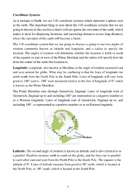
Longitude: Longitude, also known as Meridian, is the angle of rotation measured east
and west around the globe. What may be confusing is that the lines of longitude run
north-south from the North Pole to the South Pole. Lines of longitude will vary from
positive 180° east to -180° west measured relative to the line of longitude of 0° which
is known as the Prime Meridian.
The Prime Meridian runs through Greenwich, England. Lines of longitude west of
Greenwich, England up to and including 180° are represented as a negative number or
as a Western longitude. Lines of longitude east of Greenwich, England up to, and
including 180°, is represented as a positive number or as an Eastern longitude.
Latitude: The second angle of rotation is known as latitude and is also referred to as
a parallel. Parallels measure north to south on the globe, and the lines run in parallel
to each other east and west from the North Pole to the South Pole. The equator is the
latitude of 0°. Lines of latitude measure from positive 90° north, which is located at
the North Pole, to -90° south, which is located at the South Pole.
3