
Page 13 - California Diving and Surfing
P. 13
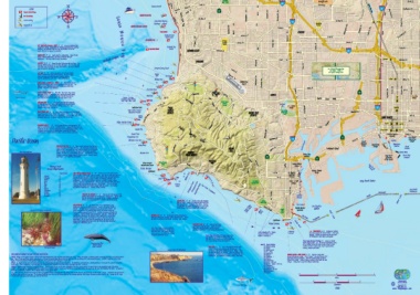
HAevremosa 190th St Columbia 405 DomingCSueUz Hills Long Beach Bl South St
Del Amo Bl Reg. Park University Bl Metro Blue Line Candlewood St
Hermosa Beach Anita St 107 Ness Ave
LEGEND HSetrondo Beryl St 710
REDONDO BREAKWALL Western Ave Wilmington Ave Del Amo
J Popular Scuba Diving Normandie Ave Alameda St
Good Snorkeling Sa n ta M o n ica B a y King Harbor Marina Harbor Dr 110 Del Amo Bl
Favorite Surfing Fisherman’s Wharf Anza Ave Bl Santa Fe Ave
Maple Ave Van SPoauvtihliboany River Trail
Kayak Put-ins REDONDO SUBMARINE CANYON
Torrance Atlantic Ave
PEARL STREET Vermont Ave CARSON San Antonio Dr
Redondo Beach Bixby Rd
State Beach Torrance Bl 213th St Wardlow Rd
Carson St FoLrossaeADeneFtgraeailnleeskdoC'BoiuksenMwtyaapyTsroafMilsap
OLD REDONDO PIER #3 DFCaeelsnhAtimeorno Denker Ave Carson St
Sepulveda Bl 405
RAT (Right After Torrance) BEACH 10’-25’ Access via Malaga Cove PALAWAN WRECK RedoBneadcohCity Catalina Ave REDONDO BEACH Ave Avalon Bl
sshaaannlfddmy.oobTneha,icsahnadernegatarirysi.beaxlRpdooi,cskweydhirtleoeeebfsaastatrreearyliinsesha.anbdithedaliwbiutthrkeesltpobnastsh,eopaleye, TORRANCE
MALAGA COVE 10’-35’ Sandy beach or rocky entry. Angel sharks, 223rd St
octopi, colorful nudibranchs, and sheep crabs live amongst Via
gorgonians. This area makes for good snorkeling. Redondo Canyon Arlington 228th St Wardlow
sHiAtGeGhERasTYd’ifSficu10lt’a-c3c5e’ss aNtatmheedVfioarClohcinaol mdiirlltiopnaatihre.wThhoe lriovcedkshheraev.e kTehlpis
aanndd tshhueespgcoroadbfso,rbsignobrlkaeclkinsge.a slugs, and lobsters. This reef is shallow 1200’ Torrance County Beach SkypaLrokmitDarBl Main St Los Angeles River
FLAT ROCK 25’-40’ Access via path at end of Paseo Del Mar 600’ L.A.
leads to boulders and rocky reefs with kelp. All kinds of kelp 120’ MRaelaegfa Rat Beach ZamFipeeldrini Narbonne Ave Willow Willow St
sfotraersfitshcr,enautduirbersanincchlus,dianngdschreaebpsh.eaGdo,ohdaslinbourtk,elloinbsgtetorso,. 300’ Malaga Cove Eshelman Ave Magnolia Ave
lMfGouRbalAlsryTtg-IeAaertnsWec, rSRsuhtEsCehteKeapds(h,MetdahAedicRc,okGamAnkTpedEolpsSa,inTn.wegmhWwiocnrRheeEcscCk.aKni)sma3a3hk'aevheWenrrtheocackradflritcoomofbi1na9ds3.s2, oTfhf e Figueroa St Lomita Bl Pacific Ave
TaAhtVoeApLlOoscNaan&tkioCinRnAi1sN9Ej5u4Ws.tRoEIuCttKmsiad6ke5e'osffIonTrhdigiscrae3ta0ot0r'tPraosiihnniitpnogwffiftoChrhawisrwlaeirccgkkedRcidvri,annge. 60’ Atlantic Ave
and it can be swum to from there. The kelp forest is rich. 30’ Orange Ave
INDICATOR POINT 10'-45' About 300 yards from the viewpoint, Hill St
okapetlaprlaeaiylnelderaebdsigsiddreooicwnknsr,itcwohh,aecsroheoollrowebasettneetrrrssy,.,hwalhibicuht,wcialllitcaokbeaysosu, atnodthick Flat Rock Point 103
rPaAnLOgSe fVrEoRmDEnSoPrtOhINoTf P10a'los-7V0e'rdeEsntPeorinftrotmo RLuensaodrtaPBoaiyntt.o keTlhpisbeisdstywphicicahlly a
Blue Shark shallow dive, which is also good for snorkeling. Caution: West swell can be Approx. location Bluff Cove LOMITA PCH L.B. City
extremely heavy, esp. in winter, and there can be currents. of Avalon & Crane Wreck: College
33047.38N 118025.67W MaLcahkaedo L.AC.olleHgaerbor
Bl SoBuothtaCnoicast HKaernboMraRlleogy./
Dr Garden Rd Wilmington Bl
Park
Indicator Point PALOS 710 Anaheim
PSahloosreVleinrdeePsrEessteartvees VERDES
ESTATES ROELLSINTAGTHESILLS 10th St
Epping
Wreck Rd Bl LONG BEACH 7th St
5th St
DaOnMdIiNtAiTsOvRisWibRleECfrKom0'th-e201'20'Thhisigbhigblgurfafianbofrveei.ghtJeargrgaend airgornousnhdipinpa1r9t6s2are Palos Verdes Point Palos Pacific
naawufdaaibsbuhrlaoanutcslhosswp,oottfidfwoer.hicclChoasuteht-ieuorpne:paShruoertagotgyrlweaapisthhteraws,davoeezsspeneacrvioaaulrlniyedtfiojearsgcgroieglodhrtwfuhrleecrke.. This is Verdes
Lunada Bay Harry 1st St Broadway
Resort Point Crest
Honeymoon Cove Transit Mall
Christmas Tree Cove
Pacific Ocean HillsRd 110 47 Ocean Bl Harbor CataTleinrma iEnxaplress Ocean Bl
Sandy Point Lagoon Long Beach
Point Vicente Lighthouse Cerritos Channel Gerald CoCnevnentetrion
Neptune Cove DeBsrmidogned DoMwanrtionwan
CswtHaeRlelIspSTadMnirdAtSkpeaTlRtphE,EaaCntOd2V8uE0s0u10aP’llays-e4to5h’eDebleDMsitvaevrr.issiebnTilhtiteeyruCanrhdoreuirsnwtdmattahesreTfrPeeVaetPuCeronevsienmvsiuianlaia. RHOILLLLISNG StaRtoeyBaleaPcalhms Dr E Terminal Island QuBeerindsgweay Island
SaTohpnpiadoslneoigysceetas,o,ptpario.enpeeufmilGsaoohrno,gdeaasns,mndkeoecrfyokihsleoholrilnfeaugrlleimtbahl,puraeeotlbutsagh,nhoSduopeugadthn.giistohbail.sshoafIwnealvste,urctrehebsersganatuertsibcainoldwcilr,uidese:, PoiWnhitte Grissom
PALROASNVCEHRODES 213 CrTuerismeinSahlip Long Beach Queen Mary
ofAtqhueaPriaucmific CrTuerismeinSahlip
6th St Gaffey St 47
PORBTEUNGUDESE 9th St
OceAanveTreamgepeLroactaulres IntPeropinrettViviceeCnetneter PointPaVrikcente Miraleste HarbCoerntVeilrlage CLhoanngnBeelach
Point Vicente Long Point
Point Vicente PspOoINtTisVIvNiCaEtNhTeE “FISCHaIrNdGiaAcCHCiEllS”S p1a0t’h-o1r00b’y boBaeta.chTahciscessitsetiostahiwsifdaevocroivtee,dbiuvte it is 30’ InsPpioPrrotartutiguougneusePesoiePnoCtionvte Abalone CoveDr W Dr Los Angeles Harbor BlL o s A ng e le s M a in Ch a nne l VinceBnrtidTgheomas
5577 best on the east side, where there are rocks, boulders, kelp, and good visibility. Lighthouse 60’ Portugues MMaursietiumme
56 Tnrahoupcedakirifborirscaohknf.scwfhekasaes.lthpurrTboheacesgkskos,eraglapbonondfuoiarmten2us5tcsth0faeymnaadtorusrd,rese.sscouasDlteilvño(iponAsrgi,ltoisasntsrgg,aogswoawdbrieimfbrrar)oylm.dai,nnToheepamisarolsaenhryioeeeras,e,viscaalnrmeidaoorusstout to 120’ PortVsill'agOeCall
JFaenbruuaarryy 555857 caoremgmroenaltyfdorivsendoOrckteolibnegr ttoooD.ecCemaubteirond:uSritnrgonSgancutarrAenntasw.inds. The shallows NWewrbecerkn San Pedro Escarpmente Bend CForuinentydsPhaiprk Long Beach Harbor
March 60 Breakwater
AJMupanryeil 56661329 WRECK OF THE SAUSILITO 10'-25' Sunk in 1932, the remains of the 300’ 25th St Patton Ave Pacific Ave BLorneagkBweaatcehr
July 58 ilwonrbtesocttkehrosefastnuhrderovSuaarnuidosiuinlsigtokaearlpreeafosinrtertsehtwecnrsoepavretinrugrae.sshiSnachlalaolwbloiptastr,hesaeh.weerHpeahclekiba.udt, come PoWinthiPteark Middle
SANOceuotpvgoetubmesemtbrberer twwOhLahDetaMeflearAssllR)paI.NraesELsTpAhrvNeoeDtraeyrc1en0tae’edra-erf5moi0nra’ipntrhseJevuriaresiltmalitbniieggvlreoawlwyteiospfontrriswmst(ieinnnrdoessri,dtthueaeniondtfoMtfehlaaaertciusknpreoerlfiarntnogrcda,k,fsyfgoicruka.etyhlpTihne CMaabrriinllao Queen’s Gate
December (cofonrprueeeilssaktignnsio,gcwgsa)nol.lodwnegrEneleclgockoot,rkrwgiincohgnticioaahrtnpretsehdtpoeaonrrstadteaysdrsalfyiotschh5c,a0ad'oscia,otnouhparaiclu,lhylnino"ufsdl,siibgielrhevaletnrgucrbphaa"ssr,ssa,dtniahvdneadrtastgwwaleemhraeoestafirseh
never found. This is a good area for snorkeling too, but access to the
Lobsters In Eel Grass At Malaga Cove ppaarrtkliyngpalovtedispdaitfhfiwcualyt tthoagtelteatdo.s to the shore below the huge Marineland 600’ kAeBlApLOaNnEdCrOoVcEks.10F'am-6o0u's foBreancuhmoerrobuosatkedlipvefoarmesotnfgissht, AGnagteels Boat Launch LosHAarnbgoerles
plus invertebrates. Snorkeling from shore. Caution: Park CabArqiluloarMiuamrine Breakwater
Tthhee whialllkdofrwonmttohtehneecaorveestisfeteoupgarhkwinigthissc0.ub8a Mgei,arp.lus
San Pedro
1200’ Lighthouse Angel’s Gate
BBUuCchHaAnNoOnN RReEeEfFa7n0d’it-s90b’eauAtitfu2l0g0oyldaerdnsgoofrfgoolndiaMnarfainnesl.andDiivsers Point Fermin
will also see sheephead and halibut (in spring), plus scallops.
Naethacosectiseeee:srsdD,aiucvmeceoetsssoitstledtasiocv.ketrhoDsefivpaeerncekctfaieerysresatPkoosarblaodolsaisftofViecignruidvltteeos PanORchTUoGrUaEgSeEinBEsNaDnd20a’nd-8ro0c’ks.BoaPtopduivlaerwfiotrhggaomoed Cabrillo Beach
Peninsula underwater scene. fyieslhloewrmtaeinl,, awnhdolfoibnsdtehraslibiunta, npdelaagroicusndsutchhe akselp forest.
TMlorceaayiltlseerdtooarbteRBaoacxrhbbuaarrtyaPSStt.t.aFnedrmin (TiWdearRniipnsg): hhL.uavnAet.iknegBl.pREaAHnKadWlipbAurTotEvRaidreetolfoo3bu5sn'tderoBvhreaerbaitkthaweta.staenrGodboonduelnadiregrhst
Royal Palms State Beach The Royal Palms Hotel Pt. Fermin Wrecks: the breakwater, especially in springtime.
wtlohatisss osafmregaaosohisdedsstubirlylfibanesgat,uodrtimivfuinhl,gewraeintahdrotturideneedpso,19opl2as5l.m, bsu, tand 1111999975542911 CABShemtn.ineirteiJoscaeamnLeibsGeirrlty PBliefoeai,nctohrFGearrnomyiminnaelMtloiafre6i0nm0e’aLyifobeueRtt.eafukNgeone,mPeaxtrc.ienpeFteirnlomvbeisnrtteterob,rCbaaotbner,itiplollo,ant
1111999943332056 LCNMihbeaelaskrroatcnywaseGliirl(?) rockfish, mackerel, perch, kelp, sand or spotted bass,
Photo By Rhu Maggio Migrating Gray Whale WVeHrdITeEsPPOeInNiTns1u5l’a -w4i5t’h paThrkisinigs trihgehotnblyy tlohceawtioanteor.n PTahleos 1928 Washentaw corbina, croaker and halibut.
(SNouortthhininWSipnrtienrg), manberuoesdrtiawbdyraiarvenmienclsghs,psip,srlisun2esg0a0sncuyiunamcrteudhrmsoebussesthrrisaan,lilvgoleohwrbttsseo.tbuerrtaDsita,vetsesrc4sia0n’lalcorlpuedsdel,iipnkategnhly.dbatotTochtsfeoitrnpaedir.s, 111999222626 DSCaliaevrridreamCo(.n12tM86e-yteorn()2510-ton)
1922 Virginia Olson
Looking Toward Old Marineland 111988028988 PDRaoenrstpuliabgenadde(r4a93-ton)
LOS ANGELES COUNTY DIVING SEASON OVERVIEW: CFeGenoArotBmdrRyiInnLwLiOgaihtrBehtEaiAdnaCivmsHinawtgroeinlfPloe.OrIrNleCoTfabusuFgEtteRei.orMnsI.:SNSitTt1ehr0oeo-nrfeg3a5anc’rnueurrsaBeelenv"aetcsrChahploorwercvroraeloacicltkkewsyLiitonshbhstotthrheeeerPDttiidv.ee".
change. Rocky shore is good for tidepool exploration.
WINTER: Winter in Los Angeles County is blessed with mild temperatures, but consistent surf affects the diving. During the winter, northwest swells repeatedly pound the coast with overhead
surf. Run-off from repetitious storms make for poor viz diving all around Santa Monica Bay, but calm stretches can bring with it clear,beautiful waters. In order to stay out of the filthy 01 2 3 4
runoff, PV and Point Dume are both gorgeous and clear during winter as well, although it is also cold. 34
SstPoRrImNsG:arLeons’Antgqeulietsedrievaedrjsukstneodw, stohaytouspmrianyglfulcakttienntsotahemsaugricfaalnddivminagkeasnfyowrhgerreeataldoinvgintghiesvecroyawsth,eeres.pecTihaellynoifrtyhowuedsotns'wtelsllmeeapchinin.e is slowly grinding to a halt and the southern hemisphere Miles
HmSoUuwMcehMvmEeRro,:raeSscutomrnomfnoegrrtsamobeuleatnhinsosrcursomowumdtehsrw,inebsuLtotssPwAVnealgllewtlheasaytsCiorsuemngrtaeyia.ntsfaoCrrfoeLwwosddsAenoggnreetleehssecCbooeoualencrth.y,’instphoeinwtastaenr,debveearcyhwbhreeraek,sbiustgtohoedrefonresvuerrfesrese,mbutot bmeacyrboewdrusnd-ofworn-yinoutrh-elifweocnodnedriftuiol nresaflomr odfivtehres.divTehres.water is 01 2
FfaeAseLlfLl:tahtFeaalwsl aiasrmltahkSeeaoanfnttedantAhtnheaevwibzienscdtasntikmsicoekairon.fgyTeuhaper, tShooeuaddtihvfeeorrinntChLoaeslibfAeonarncghieal.ecsoCaosutnrteyv,elesxpinecfilaulclytuaafttienrglahtieghseaansdonloswouptrhessswuerellssydsimteimniss,hw, ahnicdhtkheeepwsinatfetrersntooornmsonhsahvoerne'wtinbdesguant.baSyo.meDtuirminegs tthhee bfaelal,chif cyaonu be
Kilometers
Great White Shark SCALE Fabulous Guides
of Favorite Places
www.FrfaCrnoakponyrkMigoahsptsm,20Lat1pd1.s.com