
Page 9 - California Diving and Surfing
P. 9
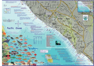
Do not reproduce this map without consent by the publisher, Frank Nielsen, Franko’s Maps. The creator and seller of this map is in no way responsible for violation of law, injury or damage in connection with the use of this map.
SEAL BEACH - N side mushy waves good for beginners SEAL BEACH Seal Beach BOLSA CHICA RD. SANTA
surfing/S side rarely breaks, but can be great when National SPRINGDALE ST.
head high or above on SW swell/Winter is best time Seal Beach Pier Anaheim Wildlife EDINGER EUCLID ST. AVE. SANTA ANA AVE. Franko’s Map of
Bay Refuge GOLDENWENT ST.
AVE. ANA
with Santa Ana winds blowing offshore Surfside SURFSIDE ,405 DR. IRVINE 241 Orange County Coast
Diving
Beach HUNTINGTON BEACH BL. River FAIRVIEW ST. BRISTOL ST. GRAND IRVINE CENTER FREEW
AVE.
Sunset HARBOR BL.
AY
DIEGO
SAN
Beach MAGNOLIA WARNER AVE.
SUNSET WARNER AVE. MAIN ST. HILL WALNUT JEFFREY
BEACH TUSTINFOUNTAIN VALLEY AVE. RD.
Great White Shark ANAHEIM BAY BREAKWATER Beg - Int 10’ - 25' BoSlEtsaanCtaBeCRmhooBpuiclegtsaraeaocuhnd TALBERT AVE. ST. FREEWAY HARBOR BL. 55 RED ALTOBNARRANCA CHUALRVVERARDDR.AVE. TRABUCO
Sandy beach entry/Heavy surf mainly in summer/ Bay ELLIS ST. PKWY. YALE AVE.
SYMBOLS KEY Lobsters and halibut in and around breakwater HUNTINGTON HARBOR Ana BAKER
MACARTHUR BL. Details of Laguna Beach Area
SCUBA DIVING Great kayaking with entry right & Crystal Cove Underwater Park
along PCH/Kayak rentals AVE. PKWY. IRVINE RD.
YALE LOOP on Reverse Side of Map
BOLSA CHICA STATE BEACH BoPlsAaCCIhFicIaCState Beach
J SNORKELING Scattered peaks best to surf in W swell with GARFIELD AVE. MAIN CENTER
E wind/Best when almost head high in winter/
Printed on Durable, Waterproof Paper
SURFING Sandy bottom AVE. RD.
BOLSA CHICA STATE BEACH 5’ - 30’ Beg - Int YORKTOWN AVE. JOHN Recreational Map for Divers, Snorkelers,
Kayakers, Boaters, Explorers
KAYAKING Entry in surf line of sandy beach/Sandy bottom/ BROOKHURSTSantaBIKE TRAIL WAYNE DR.CANYON
Halibut/Thornback rays/Surf perch/Corbina/Clams AIRPORT 133 & Others Who Love the Orange County Coast
International ADAMS AVE. RIVER For Bike Path Details FREEWAY JAMBOREE E. YALE LOOP
See Franko's Map of Upper Newport 73 RD.
33040’ N Surf Museum Orange County Trails MICHELSON
HUNTINGTON CLIFFS - As good as Orange HUNBTEIANCGHTONCHityunBteinaCgcthOonAST COSTA IRVINE DR. SAND BARRANCA True North
County surfing gets in fall and winter/Good in MESA
SW, W & NW swell, shoulder to head high/ ATLANTA AVE. Fairview MESA AVE. CAMPUS UNIVERSITY DR. 0 241
Sandy bottom Park 330 30
ANA PKWY. 270 90
VICTORIA ST. ANA Wm. R. Mason Reg. Park 240PKWY.300 Franko's 60
HUNTINGTON BEACH - Earned it's nickname, Huntington Beach Pier HAMILTON AVE. SANTA PLACENTIA AVE. COSTA SANTA Ecoligical Preserve DR. RD.
"Surf City, U.S.A." with most consistent surf break ALTON
SCALE on the Orange Co. coast year-round/Best in fall and HuntingtoHn I3SG0t’aHteWBAeYach Talbert 19TH Upper EADSR.TBLUFF Orange County Maps PKWY.
winter/Best when shoulder to head high in E wind/ Nature 17TH ST. Newport DR. 120
01234 Sandy bottom Preserve 5 BAKFOEREST LAKE 210 150
ST. Bay 180
N North DR. ,LAKE
NAUTICAL MILES DOVEIRRVIDNER.AVE. BONITA CYTNU. RTLDER.ROCK
Star
Beach
01 23 4 FRODR. D
STATUTE MILES FOREST JEROMNUIIMRLOARNDD.S BL.
HUNTINGTON BEACH 5’ - 20’ Beg - Int Newport NEWPORT BL. Orange County’s SAN DIEGO
Entry in surf line of sandy beach/Sandy plains/ Newport Pier
WE Halibut/Octopi/Surf Perch/Corbina/Pismo clams/ 60’ SAN only Natural Lakes
Sand dollars HILLS DR. The
S Lido BEACH Lagunas LEISURE WORLD
Pacific Ocean JOAQUIN
RIVER JETTIES - Juicier surfing that Huntington in East JettyIslandGoffViIScsutlgoarainraldAo*BraecafchPhoBHieaCnWlaatofcco-thd’FuisWssaChPyooevirRentomcakn’R*secCroMDeviaaievCtniS(erTroheB’BnswasoeScoawaP’eCetcosRaEoinlhCovtnEmCycetRoemBnkorv)aecaAePrylkobIaidslarnldvPtioonnBi(eeantySEPClcoooivtnMLectohrAomGaBn’eRUsaeceCNhfovAPCeo)riynsttPaLleilitCCtcCloaaevnAmeCPeooNoirnoSYtnhaoOrCCieStosNtyraTotBHneeEaa“BcDeWhealEcDNhGMEEa”rWPORRTOCOAADSMTacDAR.RTHURSAN JOAQUIN TORO RD. O’Neill
good SW swell to head high/All seasons/Sandy bottom West JettyNewport Regional Park
Beach Balboa MOULTON MISSION VIEJO
FWY.
UPPER NEWPORT BAY BalbBoaalbPoiaeBraPlebnoinaHsuaIBlarselbaaoncrdh HILLS EL LA PAZ RD. RD.
Fabulous, serene kayaking in ecological preserve/Bird MARGUERITE
120’ watching/Launch at North Star Beach or from where CORONA Gully LAGUNA WOODS
DEL MAR
the bay goes under PCH/Kayak rentals available in ALISO PKWY.
both launches WTRildAeNrnSePPsaOsrkRTATION
300’ NEWPORT HARBOR Buck Los Trancos Canyon SAN CREEK PKWY. PKWY.
Tidepools CrystalJCOovAeQUIN RD.
Boating and kayaking in one of the world's busiest small
boat harbors/Fabulous waterfront estates and yachts Laguna LAGUNA HILLS OSO
Coast
33035’ N NEWPORT PIER 5’ - 25’ Beg - Int DR.
Giant Kelp Entry in sand and surf/Best in winter/Near submarine Spiny Lobster ALICIA OLYMPIAD
canyon/Pier pilings full of life/Invertebrates/Game PARK
Juvenile Orange County 600’ fish/Bat rays/Sand sharks/Barracuda/Halibut/Sole/ PACIFIC State Park HILLS ALISOCORRIDOR PACIFIC
Adult Kelp Forest Creatures Caution: Fishermen casting lines from pier EClOMAorSo TCanyon
Laguna
NEWPORT POINT - Big left break during Greater Laguna Beach Dive Sites J Coast Aliso Wood Canyon VIEJO
S & SE Baja hurricane swells/Best when overhead+ Wilderness &
Garibaldi late summer or fall/Sandy bottom See side 2 for details: Wood
California State Fish Park
WEST JETTY “THE WEDGE” Creek
PKWY.LA PAZ
AVERAGE WATER TEMPERATURES CORONA DEL MAR (BIG CORONA) EMERALD Canyons
Regional
Topsmelt Black Surfperch LITTLE CORONA 1200’ BAY LAGUNA Laguna
HORSE RANCH (It’s Gone) Heisler Park Niguel
San Dana Newport CRYSTAL COVE UNDERWATER PARK Aliso Reg. Park
Point Beach
Rock Wrasse Sardines Clemente 58 Park BEACH
57 60
Walleye Cormorant January 57 57 60 CRYSTAL COVE RD.
Surfperch 59 61
February 57 62 64 REEF POINT & SCOTCHMAN’S COVE
63
Zebra Perch March 58 IRVINE COVE HWY. VALLEY
April 59 EMERALD BAY PACIFIC ISLAND DR.
Aliso Canyon
May 61 CRESCENT BAY (SEAL ROCK)
Rainbow Rubberlip June 63 66 66 SHAW’S COVE LAGUNA NIGUEL
Surfperch Surfperch July 66 68 69 DIVER’S COVE
August 68 68 69 PICNIC BEACH LANTERN DR. HWY. 74
California Harbor Seal September 66 67 68 ROCKY BEACH ,5 SanOJRuaTnECGreAek
Sea Lion Sargo October 64 65 65 MAIN BEACH CROWN NIGUEL RD.
SpSahnaiswhl Blue November 61 62 62 CLEO STREET BARGE Franko
December 59 59 60 CRESS STREET
Rockfish WOOD’S COVE
Halfmoon Starry MOSS STREET
Rockfish VICTORIA STREET
TREASURE ISLAND to ALISO BEACH SOUTH
33030’ N GOLDEN ST.
J LAGUNA SAN JUAN
Copper Pile Olive Rockfish Laguna Beach Area Details on Reverse Side of Map J
Rockfish Surfperch THREE
KelpSpCirnayb Bocaccio Barred TREASURE ISLAND (GOFF ISLAND) 10 - 25’ Beg ARCH BAY CAMINO CAPISTRANO
Sand Bass
DEL
Blacksmith OBISPO
AVION
Señorita Blue Shark North end of Aliso Beach Sand entry/Private beach Three Arch BayMuBsesaelchCove Salt Creek Beach Park
Next to dive area/Patchy reefs/Lobsters/Photogenic
CAUTION: Ocean conditions may STONEHILL DR.
Leopard Shark be hazardous. Be aware of surf, wind ALISO BEACH 10’ -25’ Beg - Int DEL
Blue-Gboabnyded White Seabass Great Sculpin and currents. See lifeguard or park Sand entry at south end of beach/Reefs/Rocks/
Female staff for direction and advice. Ledges/Surgy surf/Lobsters/Garibaldi/Moray eels DANA POINT
MaleClinKgeflipsh Emergency: Dial 911 PCH
BGloabcykeye Opaleye THOUSAND STEPS BEACH 5’ - 30’ Beg - Int * Cave COAST
Actually just 220 stair steps to beach/Reefs/ ***
Spotted Male See: Franko's Map of Kelp/20’ wide by 8’ high arch on north side, 300’ San JuaDnanRDaoacnCkDaosavHnePaaorPibanProtokirnt CAPISTRANO AVE.
Scorpionfish Kelp Greenling Orange County Trails from beach amongst rocks which break surface CaRpiesgtiroannalo PBaerakch BEACH
Giant Sea Bass Popeye Orange County Surfing SALT CREEK - Great barrels on days when the surf
(Black Sea Bass) Catalufa Newport Harbor and is 2' overhead in a SW, W or NW swell/Preferred
Upper Newport Bay in E Santa Ana wind/All seasons, but fall and spring are
Lingcod South Coast Wilderness best/Bottom is sand and rock in places HISGaHn WAY EL PICO
CAMINO
Juvenile Female Barracuda SAN JUAN ROCKS 10’ - 25’ Adv
Sheephead Rocky shore entry off Dana Point/Dolphins/
Purple Eel Cabezon Gorgonian Migrating gray whales near/Lobsters/Scallops/ HOLE-IN-THE-FENCE 20’ - 50’ Int
Urchin Grass Octopus Sea Fan Kelp bass/Opaleye/Garibaldi/Caution: Usually Beach entry/Scattered reefs/Sand/
poor visibility/Currents/Boats game fish/Halibut/Sheephead
Kelp Bass Clemente REAL
(Calico Bass) DANA POINT HARBOR NORTH SAN CLEMENTE BEACH 10’ - 40’ Int
Horn Shark California Giant Kelpfish Boating and kayaking in beautiful harbor and Beach entry/Scattered rocky reefs offshore/ SAN
outside harbor to Dana Point/Easy kayak launch Game fish/Halibut/Bat rays
Green Moray Eel Thornback Halibut White Plumed for dive trip to San Juan Rocks CLEMENTE
Anemone Sunflower Ray Anemone City
Bat Star
33025’ N Star Spiny Treefish Beach
Lobster Strawberry
Sea Anemone and lots more at www.frankosmaps.com SOUTH SAN CLEMENTE ROCKS 5’ - 40’ Int
Cucumber Boat or kayak entry over 1 miles offshore (visible
Ochre Bat Ray Yellowtail Copyright 2005 by Frank M. Nielsen 1701 Fraser Circle, Corona, California 92882 Note: This Map is Not Intended for Navigation from pier)/Rocky reef breaks surface/Game fish/
Seastar 118000’ W “Franko’s Maps” email: frank@frankosmaps.com website: www.frankosmaps.com 117045’ W Halibut/Bat rays/Lobsters deep in their holes
Shovelnose Guitarfish C-O Turbot Crowned
118010’ W Urchin 118000’ W 117055’ W 117050’ W 117040’ W