
Page 60 - World Airnews Magazine June 2020 Edition
P. 60
NEWS DIGITAL
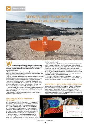
DRONES USED TO MONITOR
GLACIER LAKE FLOODING
lake level, Wolken said.
“The main issue is that its ice covered so we can’t really see the
Worldwide impacts of climate change have been clearly water as it fills up the basin on a seasonal basis,” he explained.
outlined and forecasted in general. But on the ground, in specific “WingtraOne covers a large area, efficiently and provides data that
locations, the way changing temperatures play out presents is high quality in terms of visualization and location accuracy.”
complex challenges. Key to all of this is how Mendenhall Glacier functions as a dam
In Alaska, for example, teams of researchers monitor glacier that contains the water in the basin. When the water gets too high,
changes, as well as avalanche and permafrost issues that lead to a it either flows over it or pushes it up from below due to massive
range of impacts on communities. amounts of hydraulic pressure that builds up.
Gabriel Wolken is a research professor at the University of Alaska “And then, in a catastrophic event, the water drains,” Wolken
Fairbank’s climate adaptation science centre and manager of the explained. “The entire lake drains over about a day and a half, and
state of Alaska’s climate and cryosphere hazards programme. floods the infrastructure and community down below.”
One of the big projects his research team is working on now
involves using drone data to visualise and predict a glacial lake’s
activities. Specifically, they need to know how its seasonal flux PREVENTING THE WORST CASE WITH THE BEST SOLUTION
impacts a nearby community and its vital infrastructure. Glacial lake outburst floods (GLOFs) began in 2011. The flooding
They’ve been working since 2015 through challenging conditions has damaged infrastructure and homes in the valley by Suicide
with various aerial survey methods, and in 2019 Wolken learned Basin. In 2015, Wolken was part of the first assessment of the
about WingtraOne. area. In 2018 more agencies - including the US Geological Survey
He recognised this as a new opportunity for more frequent, Field Office in Juneau and the International Arctic Research Centre
high-accuracy data capture among others - started to get involved.
HOW COULD BIG, SLOW GLACIERS FLOOD A
COMMUNITY?
Just outside Juneau, Alaska, sits the Mendenhall Glacier, a
massive body of ice stretching 21 km (13 mi). It was once
connected to another body of ice, called Suicide Glacier.
But over the past 80 years, Suicide Glacier has retreated.
In the wake of this movement, it left a piece of itself in a
deep basin. Beneath this remnant ice, the ‘Suicide Basin’
reservoir fills with water. All of this is held in place by the
Mendenhall Glacier, which is still sitting right next to it.
This point - where the basin and Mendenhall Glacier
meet - is the target area where the team is conducting
many lines of remote sensing to detect the change in the
World Airnews | June Extra 2020
— 12 —