
Page 13 - Cracking Walks - Energetic
P. 13
Continue ascending then take the contouring path to the left of Blaen-yr-henbant hill ahead. Pause at themarkerpost B fortheBeaconsWaypathascendingtotherightnearCrugMawr.
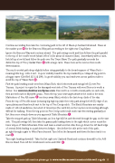
Ignore the Beacons Way and continue ahead. The path swings north and then follows the path parallel to the top of the conifer wood (what’s left of it) for about 45 minutes (3km). Immediately after a cairn, fork left up a low hill and follow the path over Pen Twyn Mawr. The path gradually ascends the distinctive top of Pen y Gadair Fawr C with a large cairn. Pause here as the next section needs determination.
The much eroded path drops slightly before rising gradually to the broad expanse of Waun Fach – meaning little bog. Little it isn’t. In poor visibility head for the top marked by a collapsed trig point in a boggy crater (Grid Ref: SO 216 299). In good visibility you can head west across pathless tufts to avoid the top of Waun Fach D .
Find the path heading south west from Waun Fach, which descends and swings left (S) over Pen Trumau. A project to repair the fire damaged west side of Pen Trumau with wool fleeces is worth a detour. See www.woollenline.wordpress.com. Descend to a col with several paths on each side, then ascend south to Mynydd Lysiau. From the top your next target ahead to the south is the mini Matterhorn of Pen Allt-mawr E one hour away (4km), which is the last steep climb of the day.
From the top of Pen Allt-mawr (meaning big high top) take the rocky path along the left (E) edge of an open plateau and head south east to the top of Pen Cerrig-calch. The Black Mountains are mainly made of old red sandstone, but a belt of limestone (the calch bit) on the top here is interesting although difficult for walking. From the trig point on Pen Cerrig-calch head south east descending gradually at firstthenmoresteeplydownasyouapproachTableMountain F .
Take the stepped path up Table Mountain, an Iron Age hill fort and descend through the gap on the east side. The path swings left, then take the grassy path leading down to the right which curves round the lower slopes of Table Mountain. Enter and leave a small wood at stiles then go down the left hand edge of several fields leading to a path between hedges. 10m before the stile at the end of this path,
go right through a gate to Wern Farm beyond. Turn left at the farmyard and down the farm track to a road .
Turn right heading downhill. Take the first right into Llanbedr Road and continue downhill to the A40 Brecon Road. Turn left for Crickhowell centre and CRiC H .
For more information please go to www.walkersarewelcomeincrickhowell.org.uk 11
G
