Page 311 - Geosystems An Introduction to Physical Geography 4th Canadian Edition
P. 311
 A Large-Scale Look at Vancouver Island’s Climate
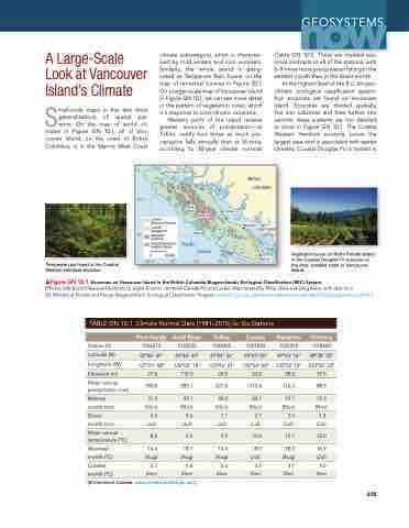
Small-scale maps in this text show generalisations of spatial pat- terns. On the map of world cli- mates in Figure GN 10.1, all of Van- couver Island, on the coast of British Columbia, is in the Marine West Coast
climate subcategory, which is character- ised by mild winters and cool summers. Similarly, the whole island is desig- nated as Temperate rain Forest on the map of terrestrial biomes in Figure 20.7. On a larger-scale map of Vancouver Island in Figure GN 10.1, we can see more detail in the pattern of vegetation cover, which is a response to local climatic variations.
Western parts of the island receive greater amounts of precipitation—at Tofino, nearly four times as much pre- cipitation falls annually than at Victoria, according to 30-year climate normals
Port Hardy
Coastal
Western Hemlock Coastal
Douglas Fir Mountain Hemlock
Coastal Mountain- heather Alpine
0 50KM
Gold River
Tofino
Pacific
Comox
BRITISH COLUMBIA
Nanaimo
VANCOUVER
Victoria
2201 m
now
(Table GN 10.1). There are marked sea- sonal contrasts at all of the stations, with 6–9 times more precipitation falling in the wettest month than in the driest month.
at the highest level of the B.C. biogeo- climatic ecological classification system, four ecozones are found on Vancouver Island. ecozones are divided spatially, first into subzones and then further into variants; these patterns are too detailed to show in Figure GN 10.1. The Coastal Western Hemlock ecozone covers the largest area and is associated with wetter climates. Coastal Douglas Fir is limited in
Chapter 10 Glob
al C
lim
ate
Sys
tem
s
275
g
e
o
s
y
s
tem
s
50°N
49°
CANADA USA
Temperate rain forest in the Coastal Western Hemlock ecozone.
128°W
127°
126°
125°
Wettest 31.2 month (cm) (Nov) Driest 5.4 month (cm) (Jul) Mean annual
8.6
temperature (°C)
Warmest 14.4
month (°C) (aug)
Coldest 3.7
month (°C) (Dec)
[Environment Canada, www.climate.weather.gc.ca/.]
18.1 (aug) 1.6
(Dec)
Ocean
Vegetation cover on North Pender Island in the Coastal Douglas Fir ecozone on the drier, leeward coast of Vancouver Island.
▲Figure GN 10.1 Ecozones on Vancouver Island in the British Columbia Biogeoclimatic Ecological Classification (BEC) System.
[Photos (left) elena elisseeva/Shutterstock; (right) Boomer Jerritt/all Canada Photos/Corbis; Map created by Philip Giles and Greg Baker, with data from
BC Ministry of Forests and range, Biogeoclimatic ecological Classification Program, www.for.gov.bc.ca/hre/becweb/resources/maps/GISdataDownload.html.]
TABLE GN 10.1 Climate Normal Data (1981–2010) for Six Stations
Station ID
latitude (N)
longitude (W)
elevation (m)
Mean annual precipitation (cm)
Port Hardy
1026270 50°40′ 49′′ 127°21′ 58′′
21.6
190.8
Gold River
1033232 49°46′ 44′′
126°03′ 18′′ 119.0
285.1
49.1 (Nov) 5.6
(Jul) 9.4
Tofino
1038205 49°04′ 56′′ 125°46′ 21′′
24.5 327.0
49.2 (Nov) 7.1
(Jul) 9.5
15.0 (aug) 5.0
(Dec)
Comox
1021830 49°43′ 00′′ 124°54′ 00′′
25.6 115.4
20.1 (Nov) 2.7
(Jul)
10.0
18.0 (Jul)
3.5 (Dec)
Nanaimo
1025370 49°03′ 16′′ 123°52′ 12′′
28.0 116.5
19.7 (Nov) 2.5
(Jul)
10.1
18.2 (aug) 3.1
(Dec)
Victoria
1018620 48°38′ 50′′ 123°25′ 33′′ 19.5
88.3
15.3 (Nov) 1.8 (Jul)
10.0
16.9 (Jul) 4.0 (Dec)
275


