Page 417 - Geosystems An Introduction to Physical Geography 4th Canadian Edition
P. 417
  Chapter 12 The Dynamic Planet 381
 Pangaea (p. 363) continental drift (p. 363) plate tectonics (p. 363) mid-ocean ridge (p. 363) seafloor spreading (p. 365) subduction zone (p. 366)
15. Brieflyreviewthehistoryofthetheoryofplatetec- tonics, including the concepts of continental drift and seafloor spreading. What was Alfred Wegener’s role?
16. What was Pangaea? What happened to it during the past 225 million years?
17. Describe the process of upwelling as it refers to magma under the ocean floor. Define subduction, and explain that process.
18. Characterise the three types of plate boundaries and the actions associated with each type.
■ Draw the pattern of Earth’s major plates on a world map, and relate this pattern to the occurrence of earthquakes, volcanic activity, and hot spots.
Earth’s lithosphere is made up of 14 large plates, and many smaller ones, that move and interact to form three types of plate boundaries: divergent, convergent, and
transform. Along the offset portions of mid-ocean ridges, horizontal motions produce transform faults. Earth- quakes and volcanoes often correlate with plate bounda- ries. As many as 50 to 100 hot spots exist across Earth’s surface, where plumes of magma—some anchored in the lower mantle, others originating from shallow sources in the upper mantle—generate an upward flow. Some hot spots produce geothermal energy, or heat from Earth’s in- terior, which may be used for direct geothermal heating or geothermal power. The geologic cycle is a model of the internal and external interactions that shape the crust— including the hydrologic, rock, and tectonic cycles.
transform fault (p. 368) hot spot (p. 370) geothermal energy (p. 370) geologic cycle (p. 375)
19. What is the relation between plate boundaries and volcanic and earthquake activity?
20. What is the nature of motion along a transform fault? 21. What is geothermal energy?
22. Illustratethegeologiccycle,anddefineeachcompo-
nent: rock cycle, tectonic cycle, and hydrologic cycle.
 Looking for additional review and test prep materials? Visit the Study Area in MasteringGeographyTM to enhance your geographic literacy, spatial reasoning skills, and understanding of this chapter’s content by accessing a variety of resources, including interactive maps, geoscience animations, satellite loops, author notebooks, videos, RSS feeds, web links, self-study quizzes, and an eText version of Geosystems.
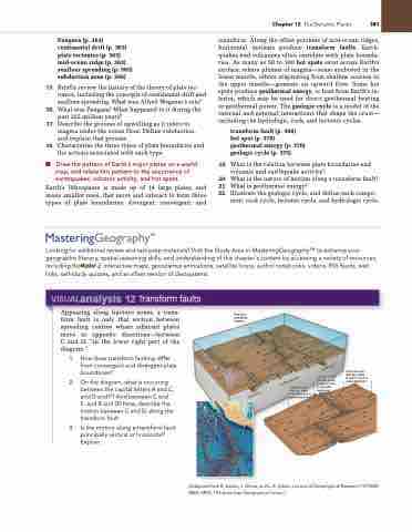
       visualanalysis 12 Transform faults
  Appearing along fracture zones, a trans- form fault is only that section between spreading centres where adjacent plates move in opposite directions—between C and D, “in the lower right part of the diagram.”
1. How does transform faulting differ from convergent and divergent plate boundaries?
2. On the diagram, what is occurring between the capital letters A and C, and D and F? And between C and E, and B and D? Now, describe the motion between C and D, along the transform fault.
3. Is the motion along a transform fault principally vertical or horizontal? Explain.
Sea-floor spreading centres
  Fracture zone (the two sides
A and B move in same direction)
A
[Adapted from B. Isacks, J. Oliver, and L. R. Sykes, Journal of Geophysical Research 73 (1968): 5855–5899, The American Geophysical Union.]
Transform fault (the two sides C and D move in opposite directions)
C
B
Fracture zone (the two sides
E and F move in same direction)
E
     D
F
Ridge
Ridge
Ridge
Ocean floor
Ridge
Ocean floor
Transform fault
Subduction
Subduction Asthenosphere


