Page 419 - Geosystems An Introduction to Physical Geography 4th Canadian Edition
P. 419
  now
geosystems
The San Jacinto
Fault Connection
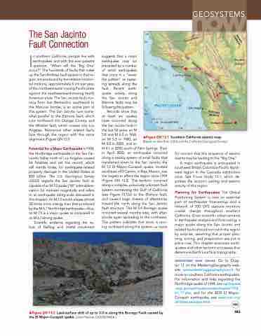
In southern California, people live with earthquakes and with the ever-present question, “When will the ‘Big One’ occur?” The hundreds of faults that make up the San Andreas fault system in that re- gion are produced by the relative horizon- tal motions, approximately 5 cm per year, of the northwestward-moving Pacific plate against the southeastward-moving North American plate. The San Jacinto fault, run- ning from San Bernardino southward to the Mexican border, is an active part of this system. The San Jacinto runs some- what parallel to the Elsinore fault, which runs northward into Orange County, and the Whittier fault, which crosses into Los Angeles. Numerous other related faults lace through the region with this same alignment (Figure gN 13.1).
Potential for a Major Earthquake In 1994, the Northridge earthquake in the San Fer- nando Valley north of Los Angeles caused 66 fatalities and set the record, which still stands today, for earthquake-related property damage in the United States at $30 billion. The U.S. geological Survey (USgS) regards the San Jacinto fault as capable of an M 7.5 quake (“M” is the abbre- viation for moment magnitude and refers to an earthquake rating scale discussed in this chapter). An M 7.5 would release almost 30 times more energy than that produced by the M 6.7 Northridge earthquake—thus, an M 7.5 is a major quake as compared to an M 6.7 strong quake.
Scientific evidence regarding the na- ture of faulting and crustal movement
suggests that a major earthquake may be preceded by a number of small earthquakes that occur in a “wave- like pattern” as ruptur- ing spreads along the fault. Recent earth- quake activity along the San Jacinto and Elsinore faults may be following this pattern.
Records show that
at least six quakes
have occurred along
the San Jacinto fault in
the last 50 years: an M
5.8 and M 6.5 in 1968, anM5.3in1980,an
M 5.0 in 2005, and an
M 4.1 in 2010, south of Palm Springs. Then in April 2010, an earthquake occurred along a nearby system of small faults that transferred strain to the San Jacinto; the M 7.2 El Mayor–Cucapah quake, located southeast of El Centro, in Baja, Mexico, was the largest to affect the region since 1994 (Figure gN 13.2). This temblor occurred along a complex, previously unknown fault system connecting the gulf of California (see Figure 13.12a) to the Elsinore fault, and caused large clusters of aftershocks toward the north along the San Jacinto fault structure. The M 5.4 Borrego quake occurred several months later, with after- shocks again spreading to the northwest. This pattern indicates that strain is mov- ing northward along the system—a cause
     ▲Figure GN 13.2 Land-surface shift of up to 3.0 m along the Borrego Fault caused by the El Major–Cucapah quake. [John Fletcher, CICESE/NASA.]
for concern that this sequence of seismic events may be leading to the “Big One.”
A major earthquake is anticipated in southwest British Columbia-Pacific North- west region in the Cascadia subduction zone. See Focus Study 13.1, which de- scribes the tectonic setting and seismic activity of this region.
Planning for Earthquakes The global Positioning System is now an essential part of earthquake forecasting, and a network of 100 gPS stations monitors crustal change throughout southern California. given scientific advancements in earthquake analysis and forecasting, a major quake along the San Jacinto and related faults should not catch the region by surprise, assuming that proper plan- ning, zoning, and preparation are put in place now. This chapter examines earth- quakes and other tectonic processes that determine Earth’s surface topography.
geosystems now online go to Chap- ter 13 on the MasteringGeography web- site (www.masteringgeography.com/) for more on southern California earthquakes. For information and links regarding the Northridge quake of 1994, see earthquake .usgs.gov/earthquakes/states/events/1994_ 01_17.php, and for the 2010 El Mayor– Cucapah earthquake, see www.scsn.org/ 2010sierraelmayor.html.
383
▲Figure GN 13.1 Southern California seismic map. [Based on data from USgS and the California geological Survey.]
 121°
      Northridge
Los Angeles
Mojave Desert
Salton Sea
     120°
0
El Mayor–Cucapah
PACIFIC OCEAN
25 50 KILOMETRES
San Diego
Borrego
    119° 118° 117°
     Nevada California
Garlock fault
35°
S
A
N
A
N
D
34°
R
A
S
F
A
U
E
e
T
W
h
i
L
t
t
i
r
S
f
a
a
Z
ult
n
O
a
E
33°
J
s
i
n
t
c
o
E
o
l
f
a
i
n
N
a
u
l
r
t
e
f
u
l
t
32°
California MEXICO


