Page 420 - Geosystems An Introduction to Physical Geography 4th Canadian Edition
P. 420
 384 part III The Earth–Atmosphere Interface
The arrangement of continents and oceans, the to- pography of the land and the seafloor, the uplift and erosion of mountain ranges, and global pat- terns of earthquake and volcanic activity are all evidence of our dynamic Earth. Earth’s endogenic systems send flows of heat and material toward the surface to form crust. These ongoing processes alter continental land- scapes and produce oceanic seafloor crust, sometimes in dramatic events that make headline news.
Natural hazards such as earthquakes and volcanic eruptions near population centres pose threats to lives and property. The world was riveted to images of mas- sive earthquakes in Haiti and Chile in 2010 and in New Zealand and Japan in 2011, as unstable plate boundar- ies snapped into new positions. (More on these events is in Focus Study 13.2 in this chapter.) Earth systems science is now providing analysis and warnings of seismic and volcanic activity to affected populations as never before.
In this chapter: We examine processes that create the various landforms and crustal features that make up Earth’s surface. Continental crust has been forming throughout most of Earth’s 4.6-billion-year existence. Tectonic processes deform Earth’s crust, which is then weathered and eroded into recognizable landforms: mountains, basins, faults and folds, and volcanoes. Such processes sometimes occur suddenly, as in the case of earthquakes, but more often the movements that shape the landscape are gradual, such as regional uplift and folding.
We begin our look at tectonics and volcanism on the ocean floor, where they are hidden from direct view. The map that opens this chapter and highlights the details of the ocean floor is a striking representation of the con- cepts learned in Chapter 12, which lays the foundation for this and subsequent chapters. Try to correlate this seafloor illustration with the maps of crustal plates and plate boundaries shown in Figure 12.18.
Earth’s Surface Relief
Landscapes across Earth occur at varying elevations; think of the low coastal plains of India and Bangladesh, the middle-elevation foothills and mountains of India and Nepal, and the high elevations of the Himalayas in Nepal and Tibet. These vertical elevation differences upon a surface are known as relief. The general term for the undulations and other variations in the shape of Earth’s surface, including its relief, is topography—the lay of the land.
The relief and topography of Earth’s landforms have played a vital role in human history: High mountain passes both protected and isolated societies, ridges and valleys dictated transportation routes, and vast plains encouraged the development of faster methods of com- munication and travel. Earth’s topography has stimulated human invention and spurred adaptation.
Studying Earth’s Topography
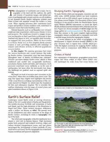
To study Earth’s relief and topography, scientists use sat- ellite radar, LiDAR systems (which use laser scanners), and tools such as GPS (which report location and eleva- tion; please review Chapter 1 for discussion of these tools.). During an 11-day period in 2000, the Shuttle Radar Topog- raphy Mission (SRTM) instruments on board the Space Shuttle Endeavor surveyed almost 80% of Earth’s land sur- face; Figure 13.1 shows examples of SRTM images (see the image gallery at www2.jpl.nasa.gov/srtm). The data acquired from this mission is the most complete high-resolution topographic dataset available and is commonly used with a satellite image overlay for topographic display.
A recent advance in the study of topography is the development of digital elevation models (DEMs) to dis- play elevation data in digital form. LiDAR, which pro- vides the highest resolution for mapping Earth’s surface, is often used in conjunction with DEMs for scientific purposes.
Orders of Relief
For convenience of description, geographers group land- scapes into three orders of relief. These orders clas- sify landscapes by scale, from vast ocean basins and
(a) Second order of relief on the Kamchatka Peninsula, Russia.
(b) Third order of relief demonstrated by the local landscape near San Jose, Costa Rica, with the volcanoes Irazu (3401 m) and Turrialba (3330 m) in the distance.
▲Figure 13.1 Second and third orders of relief. [(a) Shuttle Radar Topography Mission. (b) courtesy of JPL/NgA/NASA–CalTech.]


