Page 422 - Geosystems An Introduction to Physical Geography 4th Canadian Edition
P. 422
 386
60° 50° 40° 30°
160° 10°
part III The Earth–Atmosphere Interface 80°
70°
ARCTIC OCEAN
20°
PACIFIC OCEAN
ARCTIC OCEAN
Arctic Circle
0°140° 130° 120° 110° 100° 90° Equator
0°
50° 60° 70° 80° 90°
140° 150°
150° 160° 170° CORAL SEA 20°
30°
10° 20° 30° 40° 50°
10° 10°
20° 20°
Tropic of Capricorn
30° 30°
40° 40° 50° 50°
Plains
Local relief less than 100 m. At the ocean edge, the surface slopes gently to the sea. Plains rising continuously inland may attain the designation of high plains over 600 m.
High tablelands
Elevation over 1500 m with local relief less than 300 m except where cut by occasional canyons.
10°
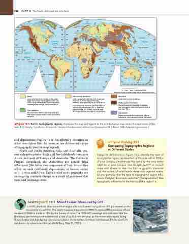
and depressions (Figure 13.3). An arbitrary elevation or other descriptive limit in common use defines each type of topography (see the map legend).
North and South America, Asia, and Australia pos- sess extensive plains. Hills and low tablelands dominate Africa and part of Europe and Australia. The Colorado Plateau, Greenland, and Antarctica are notable high tablelands (the latter two composed of ice). Mountains occur on each continent; depressions, or basins, occur only in Asia and Africa. Earth’s relief and topography are undergoing constant change as a result of processes that form and rearrange crust.
CRitiCaLthinking 13.1 Comparing Topographic Regions at Different Scales
Using the definitions in Figure 13.3, identify the type of topographic region represented by the area within 100 km of your campus, and then do the same for the area within 1000 km of your campus. Use google EarthTM or consult maps and atlases to describe the topographic character and the variety of relief within these two regional scales. Do you perceive that the type of topographic region influ- ences lifestyles? Economic activities? Transportation? Was topography influential in the history of the region? •
40° OCEAN 30°
Tropic of Cancer 20°
10°
PACIFIC OCEAN
Tropic of Cancer
ATLANTIC
60°
50°
50° 40° 30°
50°
40°
30° 20° 10°
20° 20° 20° Tropic of Capricorn 30° 30° 30°
40° 40° 40° 50° 50° 50°
Hills and low tablelands
Hills–Local relief more than 100 m but less than 600 m. At the edge of the sea, however, local relief may be as low as 60 m.
Low tablelands–Elevation less than 1500 m with local relief less than 100 m. Does not reach the sea, or if it does, a bluff at least 60 m high delimits the edge of the tableland.
40°
110° 120° 130° 140° 150° 160° 180°
0 1000 2000 3000 KILOMETRES
MODIFIED GOODE'S HOMOLOSINE EQUAL-AREA PROJECTION
Mountains
Local relief more than 600 m.
Widely spaced mountains
Discontinuous and standing in isolation with intervening areas having local relief of less than 150 m.
Depressions
Basins surrounded by mountains, hills, or tablelands, which abruptly delimit the basins.
▲Figure 13.3 Earth’s topographic regions. Compare the map and legend to the world physical map inside the back cover of this text. [R. E. Murphy, “Landforms of the world,” Annals of the Association of American Geographers 58, 1 (March 1968). Adapted by permission.]
Georeport 13.1 Mount Everest Measured by GPS
In 1999, climbers determined the height of Mount Everest using direct gPS placement on the mountain’s icy summit. The newly measured elevation of 8850 m replaced the previous official
measure of 8848 m made in 1954 by the Survey of India. The 1999 gPS readings also indicated that the Himalayas are moving northeastward at a rate of up to 6 mm per year, as the mountain range is being driven farther into Asia by the continuing collision of the Indian and Asian landmasses. [Photo and gPS installation by adventurer/climber Wally Berg, May 20, 1998.]
Equator
INDIAN
10°
OCEAN
120° 20°
30°
ARABIAN SEA
BAY OF BENGAL


