Page 421 - Geosystems An Introduction to Physical Geography 4th Canadian Edition
P. 421
Chapter 13 Tectonics, Earthquakes, and Volcanism 385
  continents down to local hills and valleys. The first order of relief is the coarsest level of landforms, consisting of the continents and oceans. Continental landmasses are those portions of crust that reside above or near sea level, including the undersea continental shelves along the coastlines. Ocean basins, featured in the chapter- opening map illustration, are portions of the crust that are entirely below sea level. Approximately 71% of Earth is covered by ocean.
The second order of relief is the intermediate level of landforms, both on continents and in ocean basins (Figure 13.1a). Continental features in the second order of relief include mountain masses, plains, and lowlands. A few examples are the European Alps, Canadian and American Rockies, west Siberian lowland, and Tibetan Plateau. This order includes the great rock “shields,” such as the Canadian Shield in North America, that form the heart of each continental mass. In the ocean basins, the second order of relief includes continental rises and slopes, flat plains (called abyssal plains), mid-ocean ridges, submarine canyons, and oceanic trenches (sub- duction zones)—all visible in the seafloor illustration that opens this chapter.
The third and most detailed order of relief includes individual mountains, cliffs, valleys, hills, and other landforms of smaller scale (Figure 13.1b). These features characterise local landscapes.
Earth’s Hypsometry
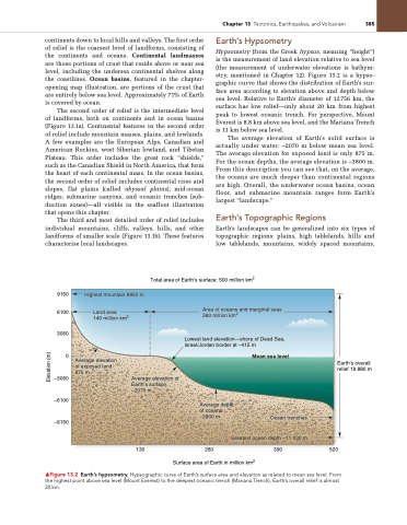
Hypsometry (from the Greek hypsos, meaning “height”) is the measurement of land elevation relative to sea level (the measurement of underwater elevations is bathym- etry, mentioned in Chapter 12). Figure 13.2 is a hypso- graphic curve that shows the distribution of Earth’s sur- face area according to elevation above and depth below sea level. Relative to Earth’s diameter of 12756 km, the surface has low relief—only about 20 km from highest peak to lowest oceanic trench. For perspective, Mount Everest is 8.8 km above sea level, and the Mariana Trench is 11 km below sea level.
The average elevation of Earth’s solid surface is actually under water: –2070 m below mean sea level. The average elevation for exposed land is only 875 m. For the ocean depths, the average elevation is –3800 m. From this description you can see that, on the average, the oceans are much deeper than continental regions are high. Overall, the underwater ocean basins, ocean floor, and submarine mountain ranges form Earth’s largest “landscape.”
Earth’s Topographic Regions
Earth’s landscapes can be generalized into six types of topographic regions: plains, high tablelands, hills and low tablelands, mountains, widely spaced mountains,
Total area of Earth’s surface: 500 million km2
    9150 6100
 3050
    0
–3050
–6100
–9150
Earth’s overall relief 19 880 m
Highest mountain 8850 m
 Land area
140 million km2
Average elevation of exposed land 875 m
Area of oceans and marginal seas 360 million km2
Lowest land elevation—shore of Dead Sea, Israel/Jordan border at –415 m
        Mean sea level
    Average elevation of Earth’s surface –2070 m
130
260 390 520 Surface area of Earth in million km2
▲Figure 13.2 Earth’s hypsometry. Hypsographic curve of Earth’s surface area and elevation as related to mean sea level. From the highest point above sea level (Mount Everest) to the deepest oceanic trench (Mariana Trench), Earth’s overall relief is almost 20 km.
Average depth of oceans –3800 m
Ocean trenches Greatest ocean depth –11 030 m
  Elevation (m)


